Publications:Newsletters/Apr2015: Difference between revisions
mNo edit summary |
mNo edit summary |
||
| (2 intermediate revisions by the same user not shown) | |||
| Line 1: | Line 1: | ||
{{DISPLAYTITLE:CIRP April 2015 eNewsletter}} | |||
<big>Issue 36, April 2015</big> | <big>Issue 36, April 2015</big> | ||
| Line 18: | Line 16: | ||
[[Image:Issue36-DoC.png|thumb|400px]] | [[Image:Issue36-DoC.png|thumb|400px]] | ||
The CIRP-Inlet Geomorphology work unit has created a database containing depth of closure (DOC) values as associated with each Wave Information Study (WIS) station hindcast that is available along each coast of the United States, including the Great Lakes. The DOC was calculated using several different methods (e.g. Birkemeier, 1985; Hallermeier, 1981; etc.) for comparison. The database is available on the CIRP Website – Products – US Depth of Closure Info (http://cirp.usace.army.mil/products/depth-of-closure.php) so that coastal engineers and planners may use the DOC calculations for beach and nearshore projects. In the future, the data will be available in the form of an interactive webtool in the CIRP Portal. | The CIRP-Inlet Geomorphology work unit has created a database containing depth of closure (DOC) values as associated with each Wave Information Study (WIS) station hindcast that is available along each coast of the United States, including the Great Lakes. The DOC was calculated using several different methods (e.g. Birkemeier, 1985; Hallermeier, 1981; etc.) for comparison. The database is available on the CIRP Website – Products – US Depth of Closure Info (http://cirp.usace.army.mil/products/depth-of-closure.php) so that coastal engineers and planners may use the DOC calculations for beach and nearshore projects. In the future, the data will be available in the form of an interactive webtool in the CIRP Portal. This product was developed on behalf of both the CIRP and RSM research programs. | ||
{{POC|(ERDC) Katherine Brutsché|Katherine.E.Brutsche@usace.army.mil}} | {{POC|(ERDC) Katherine Brutsché|Katherine.E.Brutsche@usace.army.mil}} | ||
Latest revision as of 20:55, 25 August 2020
Issue 36, April 2015
In this Newsletter:
“Overview of CIRP Regional Sediment Management Tools” held in Conjunction with Regional Sediment Management Workshop

On 26 March, CIRP researchers Ashley Frey, Mitch Brown, and Julie Rosati gave an overview of CIRP tools for Regional Sediment Management (RSM), including GenCade and the Coastal Modeling System (CMS-Wave and CMS-Flow) with application of the Particle Tracking Model (PTM). Ashley and Mitch discussed application of GenCade to Galveston, TX and the CMS to Newburyport, MA, respectively. Jason Engle and Kelly Legault from the Jacksonville District discussed application of CMS for RSM in northeast and southwest Florida, and application of sediment budget tools in conjunction with these studies. Twenty-one attendees from 8 Districts participated in the half-day workshop.
POC: (ERDC) Julie Rosati, Julie.D.Rosati@usace.army.mil
Depth of Closure Web Database Available on CIRP Website
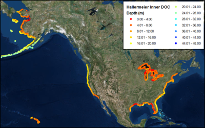
The CIRP-Inlet Geomorphology work unit has created a database containing depth of closure (DOC) values as associated with each Wave Information Study (WIS) station hindcast that is available along each coast of the United States, including the Great Lakes. The DOC was calculated using several different methods (e.g. Birkemeier, 1985; Hallermeier, 1981; etc.) for comparison. The database is available on the CIRP Website – Products – US Depth of Closure Info (http://cirp.usace.army.mil/products/depth-of-closure.php) so that coastal engineers and planners may use the DOC calculations for beach and nearshore projects. In the future, the data will be available in the form of an interactive webtool in the CIRP Portal. This product was developed on behalf of both the CIRP and RSM research programs.
POC: (ERDC) Katherine Brutsché, Katherine.E.Brutsche@usace.army.mil
Galveston Island Sand Management Plan
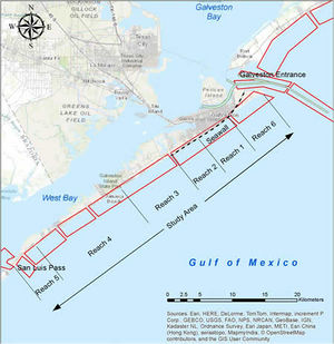
ERDC recently completed the Galveston Island Sand Management Plan for the Galveston Park Board which developed a long-term plan to manage the sands and beaches of Galveston Island, Texas. To better understand the physical processes, an updated sediment budget for the island was completed and incorporated in the Sediment Budget Analysis System (SBAS). GenCade was used to calculate shoreline change for a time period of 50 years considering various beach fill, backpassing, and structural alternatives. The sand management alternatives ranged from the present plan of reacting to storms or emergencies to a comprehensive beach fill along all of Galveston Island with backpassing plants on each end of the island. ERDC presented the plan at a Galveston Park Board meeting in November 2014 and submitted the written plan at that time. ERDC is investigating options to publish this study as a Technical Report or Special Report.
POC: (ERDC) Ashley Frey, Ashley.E.Frey@usace.army.mil
Evaluating Sediment Mobility for Siting Nearshore Berms
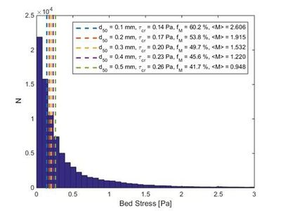
Although the practice of placing dredged material in the nearshore region is commonplace, there is not an existing simple web tool application that can rapidly produce a preliminary assessment of the sediment mobility of prospective placement sites and aid in evaluating what portion of the placed material is likely to transport. Calculating sediment mobility is the first step for engineers and planners to estimate the potential volumes of material that a placement operation might yield to beneficially nourish a wetland or nearshore region, thereby allowing stakeholders to gain support for a project. The CIRP – Inlet Geomorphology Evolution work unit has created a Matlab© script to perform the calculations using two methods to quickly assess sediment mobility relative to depth as a function of local waves and currents. Sediment mobility is estimated using linear wave theory and nonlinear stream function wave theory to provide a range of predicted mobility for various sediment sizes. Both methods are applied to 10 years of offshore wave hindcasts which are transformed to the user-provided nearshore site. Histograms are created that show the number of waves (N) and bed shear stress. In the figure below, the critical shear stress, frequency of sediment mobility, and nondimensional mobility index are noted with vertical dashed lines for a range of median grain sizes. The equations and procedure used to calculate the sediment mobility are described in a Coastal and Hydraulics Engineering Technical Note (CHETN) that is presently in review. The program is being expanded to calculate mobility from a nearshore berm by relating sediment mobility of a berm directly with depth of each size of the placed sediment. Future upgrades may include the development of an interactive web tool with automated data uploads for engineers to utilize.
POC: (ERDC) Brian McFall, brian.c.mcfall@usace.army.mil
Coastal Modeling System (CMS) and Surface-Water Modeling System (SMS) Training for the Korean Environmental Institute, 20-22 January 2015
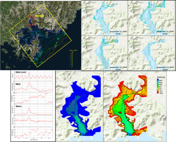
Dr. Honghai Li conducted onsite training on the CMS, developed by the Coastal Inlets Research Program, at the Korea Environment Institute (KEI), 20-22 Jan 2015. Eight scientists/engineers from KEI, Chonnam National University of Korea, and GeoSystem Research Corporation of Korea attended the training. The training included an overview of features, capabilities and limitations of CMS and the Surface-Water Modeling System. Two hands-on sessions were also conducted covering pre- and post-data processing/analysis, model setup and visualization. This technical transfer concluded an ongoing collaborative “Pilot Study on Vulnerability Assessment Model of Climate Change: Application to Korean Coast” with KEI, which will be documented in a technical report.
POC: (ERDC) Honghai Li, Honghai.Li@usace.army.mil
Engineer Research & Development Center
3909 Halls Ferry Road, Coastal & Hydraulics Laboratory
Vicksburg, MS 39180
251-635-9519