SBAS: Difference between revisions
→Downloads: - updating the links for downloading and accessing guidance documents |
|||
| (16 intermediate revisions by 3 users not shown) | |||
| Line 1: | Line 1: | ||
__NOTOC__ | __NOTOC__ | ||
{{DISPLAYTITLE:Sediment Budget Analysis System (SBAS)}} | |||
[[File:RSMlogo.png|thumb|left| | [[File:RSMlogo.png|thumb|left|This tool is funded by [https://rsm.usace.army.mil/ (RSM)]]] | ||
==A Visualization and Calculation Tool for Sediment Budgets== | ==A Visualization and Calculation Tool for Sediment Budgets== | ||
The Sediment Budget Analysis System is a free sediment budget creation, visualization and calculation tool set for ESRI ArcGIS, with versions compatible with ArcMap 10.x versions and ArcGIS Pro. Once installed, this toolbox allows users to define a conceptual budget visually by creating a series of cells and arrows that represent fluxes into and out of cells (sources and sinks). Sand placement, P, and removal, R, within cells can be accounted for. SBAS can then create quantitative "micro" (local) and "macro" (regional) sediment budgets, using a pre-defined sediment-budget equation. | The Sediment Budget Analysis System is a free sediment budget creation, visualization and calculation tool set for ESRI ArcGIS, with versions compatible with ArcMap 10.x versions and ArcGIS Pro. Once installed, this toolbox allows users to define a conceptual budget visually by creating a series of cells and arrows that represent fluxes into and out of cells (sources and sinks). Sand placement, P, and removal, R, within cells can be accounted for. SBAS can then create quantitative "micro" (local) and "macro" (regional) sediment budgets, using a pre-defined sediment-budget equation. | ||
The SBAS ArcMap toolset is available for download from the [https://rsm.usace.army.mil/ RSM Website] in the "Tools & Databases" dropdown. SBAS for ArcGIS Pro will be made available in the coming year. Legacy versions of the SBAS were developed as standalone executables for PC. For questions regarding older versions of SBAS please reach out to the contacts listed at the end of this article. | The SBAS ArcMap toolset is available for download along with additional information from the [https://rsm.usace.army.mil/ RSM Website] in the "Tools & Databases" dropdown. SBAS for ArcGIS Pro will be made available in the coming year. Legacy versions of the SBAS were developed as standalone executables for PC. For questions regarding older versions of SBAS please reach out to the contacts listed at the end of this article. | ||
==Background (modified from Rosati and Kraus, 1999)== | ==Background (modified from Rosati and Kraus, 1999)== | ||
| Line 44: | Line 43: | ||
#Intermediate Condition. Sediment budgets representing other periods create a model of coastal evolution through time, which may lend insight to interpreting present or future evolution. As examples, intermediate-condition sediment budgets may document evolution of an inlet from initial formation to a quasi-equilibrium state, or they may reveal a picture of long-term natural bypassing through a cycle of channel migration and welding of a portion of the ebb-tidal shoal to the adjacent beach. | #Intermediate Condition. Sediment budgets representing other periods create a model of coastal evolution through time, which may lend insight to interpreting present or future evolution. As examples, intermediate-condition sediment budgets may document evolution of an inlet from initial formation to a quasi-equilibrium state, or they may reveal a picture of long-term natural bypassing through a cycle of channel migration and welding of a portion of the ebb-tidal shoal to the adjacent beach. | ||
== | ==Versions== | ||
{| class="wikitable" | |||
|- | |||
! SBAS Version | |||
! Latest Update | |||
! Software Compatability | |||
! Documentation | |||
|- | |||
| SBAS Pro | |||
| July 2020 | |||
| ESRI ArcGIS Pro | |||
| [[SBAS/UsersGuide|User's Guide Wiki]], [https://erdc-library.erdc.dren.mil/jspui/bitstream/11681/44140/1/ERDC-CHL%20SR-22-1.pdf User's Guide Report (ERDC/CHL SR-22-1)] | |||
|- | |||
| SBAS Arc10 | |||
| July 2018 | |||
| ESRI ArcMap v. 10.x | |||
| [https://rsm.usace.army.mil/pubs/pdfs/SBAS_Arc10_Guide-Jun12.pdf SBAS ArcGIS 10 User's Guide (PDF)] | |||
|- | |||
| SBAS-A | |||
| 2007 | |||
| ESRI ArcView v. 8.x | |||
| [https://erdc-library.erdc.dren.mil/jspui/bitstream/11681/4979/1/ERDC-CHL-CHETN-XIV-7.pdf CHETN-XIV-7] | |||
|- | |||
| SBAS | |||
| 1991 | |||
| Windows 95, 98 & NT | |||
| [https://erdc-library.erdc.dren.mil/jspui/bitstream/11681/2242/1/CETN-IV-20.pdf CETN-IV-20] | |||
|} | |||
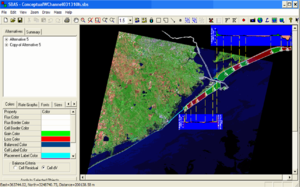
== | [[File:SBAS_overview.png|thumb|The legacy SBAS standalone PC executable window]] | ||
==Access== | |||
Download SBAS | Download SBAS | ||
*[https:// | *[https://www.arcgis.com/home/item.html?id=8686b2f460a04931a2154f83cafcabde Download SBAS Toolbar for ArcGIS 10] - updated 07 July 2020 | ||
*[https://www.arcgis.com/home/item.html?id=90576370d48f491fbddc7a15bbfb40d7 Download SBAS Toolbar for ArcPro] - updated 02 June 2021 | |||
Documentation | |||
*[[SBAS/UsersGuide|SBAS User's Guide Wiki]] - continually updated guidance for tool installation and use | |||
*[https://erdc-library.erdc.dren.mil/jspui/bitstream/11681/44140/1/ERDC-CHL%20SR-22-1.pdf SBAS 2020 (ArcPro) User's Guide] - PDF user's guide specific to the ArcPro version | |||
*[https://rsm.usace.army.mil/pubs/pdfs/SBAS_Arc10_Guide-Jun12.pdf SBAS ArcGIS 10 User's Guide (PDF)] - PDF user's guide specific to the ArcGIS 10 version | |||
[https://www.arcgis.com/home/item.html?id=90576370d48f491fbddc7a15bbfb40d7 Download SBAS Toolbar for ArcPro] | |||
==Points of Contact== | ==Points of Contact== | ||
Main POC: | Main POC: Sean McGill<br> | ||
Email: [mailto:// | Email: [mailto://Sean.P.McGill@usace.army.mil Sean.P.McGill@usace.army.mil] | ||
Secondary POC: | Secondary POC: David Perkey<br> | ||
Email: [mailto: | Email: [mailto:David.Perkey@usace.army.mil David.Perkey@usace.army.mil] | ||
Technical Issues: Rose Dopsovic<br> | Technical Issues: Rose Dopsovic<br> | ||
Email: [mailto://Rose.Dopsovic@usace.army.mil Rose.Dopsovic@usace.army.mil] | Email: [mailto://Rose.Dopsovic@usace.army.mil Rose.Dopsovic@usace.army.mil] | ||
Latest revision as of 19:26, 31 January 2023

A Visualization and Calculation Tool for Sediment Budgets
The Sediment Budget Analysis System is a free sediment budget creation, visualization and calculation tool set for ESRI ArcGIS, with versions compatible with ArcMap 10.x versions and ArcGIS Pro. Once installed, this toolbox allows users to define a conceptual budget visually by creating a series of cells and arrows that represent fluxes into and out of cells (sources and sinks). Sand placement, P, and removal, R, within cells can be accounted for. SBAS can then create quantitative "micro" (local) and "macro" (regional) sediment budgets, using a pre-defined sediment-budget equation.
The SBAS ArcMap toolset is available for download along with additional information from the RSM Website in the "Tools & Databases" dropdown. SBAS for ArcGIS Pro will be made available in the coming year. Legacy versions of the SBAS were developed as standalone executables for PC. For questions regarding older versions of SBAS please reach out to the contacts listed at the end of this article.
Background (modified from Rosati and Kraus, 1999)
Sediment budgets provide a conceptual and quantitative model of sediment-transport magnitudes and pathways for a given time period. Sediment budgets are a framework for understanding complex coastal systems, whether natural or engineered. Often, the natural condition is studied to gain background information necessary for evaluating the inlet and adjacent beach response to coastal engineering projects (see Komar 1996, 1998 for an overview of concepts and applications).
Theory
SBAS calculates cell balances based on a conservation of volume (or volume flux) equation,
| (1) |
where
= input of sediment into a cell
= loss of sediment from a cell
= volume change within a cell
= placement into a cell (e.g., beach fill or dredged material)
= removal from a cell (e.g., dredging or mining)
= 0 for a balanced cell
Units are fluxes or volumes (e.g., cu yd/year, cu m/year, cu yd, cu m) representative of the period of interest.
Applications
Sediment budgets can enter at any of four stages in project development:
- Existing Condition. A sediment budget for the existing condition is the most common type. This budget forms the basis for evaluating the impacts of planned engineering activities and the natural evolution of the coast.
- Historical (pre-engineering activity) Condition. This budget is typically constructed for comparison with the existing-condition budget. A common application of the two budgets for inlet systems is a so-called "Section 111" or similar study, in which the impacts of inlet-related engineering activities (at Federal navigation projects) on the adjacent beaches are estimated.
- Forecast Future Condition. Adapting and extrapolating the existing-condition sediment budget can assess the potential response to future projects or modifications.
- Intermediate Condition. Sediment budgets representing other periods create a model of coastal evolution through time, which may lend insight to interpreting present or future evolution. As examples, intermediate-condition sediment budgets may document evolution of an inlet from initial formation to a quasi-equilibrium state, or they may reveal a picture of long-term natural bypassing through a cycle of channel migration and welding of a portion of the ebb-tidal shoal to the adjacent beach.
Versions
| SBAS Version | Latest Update | Software Compatability | Documentation |
|---|---|---|---|
| SBAS Pro | July 2020 | ESRI ArcGIS Pro | User's Guide Wiki, User's Guide Report (ERDC/CHL SR-22-1) |
| SBAS Arc10 | July 2018 | ESRI ArcMap v. 10.x | SBAS ArcGIS 10 User's Guide (PDF) |
| SBAS-A | 2007 | ESRI ArcView v. 8.x | CHETN-XIV-7 |
| SBAS | 1991 | Windows 95, 98 & NT | CETN-IV-20 |

Access
Download SBAS
- Download SBAS Toolbar for ArcGIS 10 - updated 07 July 2020
- Download SBAS Toolbar for ArcPro - updated 02 June 2021
Documentation
- SBAS User's Guide Wiki - continually updated guidance for tool installation and use
- SBAS 2020 (ArcPro) User's Guide - PDF user's guide specific to the ArcPro version
- SBAS ArcGIS 10 User's Guide (PDF) - PDF user's guide specific to the ArcGIS 10 version
Download SBAS Toolbar for ArcPro
Points of Contact
Main POC: Sean McGill
Email: Sean.P.McGill@usace.army.mil
Secondary POC: David Perkey
Email: David.Perkey@usace.army.mil
Technical Issues: Rose Dopsovic
Email: Rose.Dopsovic@usace.army.mil