JALBTCX/PFE Getting Started: Difference between revisions
mNo edit summary |
mNo edit summary |
||
| (3 intermediate revisions by one other user not shown) | |||
| Line 2: | Line 2: | ||
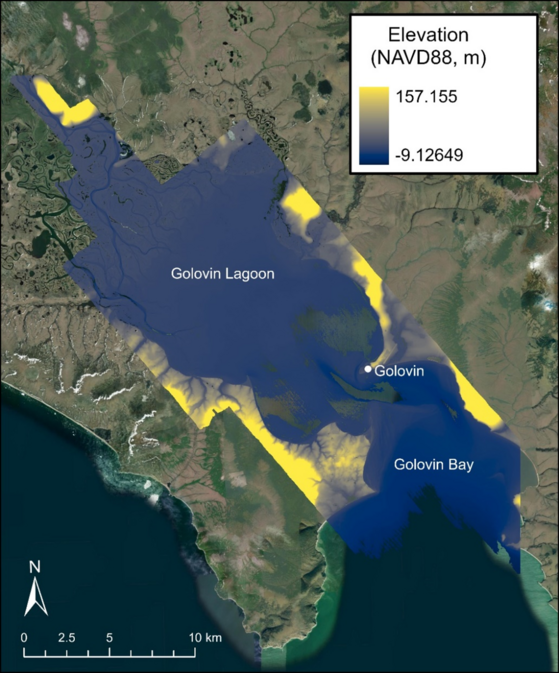
The Profile Feature Extraction Toolbox steps function like other geoprocessing tools that are native to ArcGIS Pro. To guide the user through this workflow, DEM data collected as a part of the NCMP is leveraged; the data used for this training is a 2019 DEM from Golovin, Alaska, seen in Figure 2. The data were downloaded from NOAA Digital Coast as a 1-meter resolution DEM with NAD1983 (2011) UTM Zone 3N horizontal and NAVD88 height (meters) vertical coordinate systems. | The Profile Feature Extraction Toolbox steps function like other geoprocessing tools that are native to ArcGIS Pro. To guide the user through this workflow, DEM data collected as a part of the NCMP is leveraged; the data used for this training is a 2019 DEM from Golovin, Alaska, seen in Figure 2. The data were downloaded from NOAA Digital Coast as a 1-meter resolution DEM with NAD1983 (2011) UTM Zone 3N horizontal and NAVD88 height (meters) vertical coordinate systems. | ||
[[File:DEM Coverage Golovin AK.png|alt=A GIS map of the Golovin, AK DEM coverage, displayed with a yellow-blue colormap. Elevations span from -9.13 to 157.16 meters. | [[File:DEM Coverage Golovin AK.png|alt=A GIS map of the Golovin, AK DEM coverage, displayed with a yellow-blue colormap. Elevations span from -9.13 to 157.16 meters. |673x673px|Figure 2. Golovin, AK DEM coverage (colormap) that includes Golovin, Golovin Bay and Golovin Lagoon.|none|thumb]] | ||
Important DEM considerations for feature extraction and CERI analysis include resolution and spatial coverage. Higher resolution DEMs produce smoother profiles and more accurate feature locations. For the most accurate results, DEMs with a 1 meter or higher resolution are preferable. While spatial coverage of the study site is important for capturing beach features, full coverage between the chosen landward limit and shoreline is required for the most accurate CERI calculations. The shoreline for the toolbox is created at the user-specified Mean High Water (MHW) elevation and influences multiple CERI parameters including protective width, MHW slope, beach slope, and beach width. NOTE: If coverage does not extend to the MHW elevation, the toolbox will select the elevation that is closest to the specified MHW elevation and the user is notified. This causes inaccurate shoreline location detection, leading to artificially decreased parameter values and inaccuracy in the CERI results. | |||
Downloaded DEMs can be imported into the ArcGIS Pro project using the ‘Add Data’ option underneath the ‘Layer’ section of the ‘Map’ tab. The Profile Feature Extraction Toolbox can be added via the ‘Toolbox’ option underneath the ‘Project’ section of the ‘Insert’ tab. | |||
The most recent version of the toolbox is available for download at the main page, [[JALBTCX]]. | |||
<center>[[JALBTCX/PFETransectandBaselineCreation|[Next Step]]]</center> | |||
==Useful Links== | |||
[[JALBTCX|JALBTCX Main Documentation Page]] | |||
[[JALBTCX/PFEReferences|References: Profile Feature Extraction]] | |||
Latest revision as of 14:24, 20 August 2025
The Profile Feature Extraction Toolbox steps function like other geoprocessing tools that are native to ArcGIS Pro. To guide the user through this workflow, DEM data collected as a part of the NCMP is leveraged; the data used for this training is a 2019 DEM from Golovin, Alaska, seen in Figure 2. The data were downloaded from NOAA Digital Coast as a 1-meter resolution DEM with NAD1983 (2011) UTM Zone 3N horizontal and NAVD88 height (meters) vertical coordinate systems.

Important DEM considerations for feature extraction and CERI analysis include resolution and spatial coverage. Higher resolution DEMs produce smoother profiles and more accurate feature locations. For the most accurate results, DEMs with a 1 meter or higher resolution are preferable. While spatial coverage of the study site is important for capturing beach features, full coverage between the chosen landward limit and shoreline is required for the most accurate CERI calculations. The shoreline for the toolbox is created at the user-specified Mean High Water (MHW) elevation and influences multiple CERI parameters including protective width, MHW slope, beach slope, and beach width. NOTE: If coverage does not extend to the MHW elevation, the toolbox will select the elevation that is closest to the specified MHW elevation and the user is notified. This causes inaccurate shoreline location detection, leading to artificially decreased parameter values and inaccuracy in the CERI results.
Downloaded DEMs can be imported into the ArcGIS Pro project using the ‘Add Data’ option underneath the ‘Layer’ section of the ‘Map’ tab. The Profile Feature Extraction Toolbox can be added via the ‘Toolbox’ option underneath the ‘Project’ section of the ‘Insert’ tab.
The most recent version of the toolbox is available for download at the main page, JALBTCX.