Inlets: Difference between revisions
Jump to navigation
Jump to search
No edit summary |
No edit summary |
||
| (4 intermediate revisions by the same user not shown) | |||
| Line 1: | Line 1: | ||
[[Image: | [[Image:Inlet_States-blue.png|thumb|right|400px|]] | ||
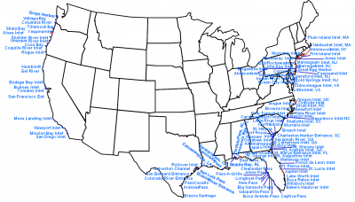
The Inlets Geospatial Databases include different spatial datasets assembled and developed by the CIRP in support of inlet navigation channel research. The | The Inlets Geospatial Databases include different spatial datasets assembled and developed by the CIRP in support of inlet navigation channel research. The data are assembled from a wide range of sources from multiple US Government authorities and scientific studies over a significant temporal coverage. The sources used were determined to be high quality products that use appropriate and up-to-date scientific methods. Some data are the only account of the information available at a particular location. Use of this product may require additional research to original sources for verification and notice of any updated information. | ||
<big> | <big> | ||
| Line 10: | Line 10: | ||
*[http://www.oceanscience.net/inletsonline/ Inlets Online] | *[http://www.oceanscience.net/inletsonline/ Inlets Online] | ||
*[http://www.oceanscience.net/inletsonline/map/map.html Link to Inlets Online Google Map Viewer] | *[http://www.oceanscience.net/inletsonline/map/map.html Link to Inlets Online Google Map Viewer] | ||
*[http://oceanscience.net/inletsonline/map/berms_online.html Link to Berms Online Google Map Viewer] | |||
</font> | </font> | ||
| Line 19: | Line 17: | ||
Back to [[Main_Page | Main Page]] | Back to CIRP [[Main_Page | Main Page]] | ||
Latest revision as of 19:39, 29 February 2012

The Inlets Geospatial Databases include different spatial datasets assembled and developed by the CIRP in support of inlet navigation channel research. The data are assembled from a wide range of sources from multiple US Government authorities and scientific studies over a significant temporal coverage. The sources used were determined to be high quality products that use appropriate and up-to-date scientific methods. Some data are the only account of the information available at a particular location. Use of this product may require additional research to original sources for verification and notice of any updated information.
Back to CIRP Main Page