Sargent Beach Lessons Learned: Difference between revisions
No edit summary |
No edit summary |
||
| Line 2: | Line 2: | ||
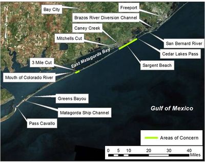
The Port of Bay City, Texas, asked the U.S. Army Corps of Engineers to develop potential structural solutions to reduce erosion of critical beach baitat and to increase protection from tropical storms in Matagorda County. The two primary areas of concern are Sargent Beach and a 2-3 mile stretch of beach on Matagorda Peninsula located about a mile east of the Mouth of the Colorado River (MCR). This two-part study investigated the coastal processes of the region and introducted several structural alternatives to reduce erosion. Phase 1 of the study investigated the coastal processes and determined which structural solutions would be evaluated further in Phase 2. Figure 1 shows a map of the project area and region. | The Port of Bay City, Texas, asked the U.S. Army Corps of Engineers to develop potential structural solutions to reduce erosion of critical beach baitat and to increase protection from tropical storms in Matagorda County. The two primary areas of concern are Sargent Beach and a 2-3 mile stretch of beach on Matagorda Peninsula located about a mile east of the Mouth of the Colorado River (MCR). This two-part study investigated the coastal processes of the region and introducted several structural alternatives to reduce erosion. Phase 1 of the study investigated the coastal processes and determined which structural solutions would be evaluated further in Phase 2. Figure 1 shows a map of the project area and region. | ||
[[Image:Fig1_studyarea_Matagorda.jpg|400px|thumb|left|Figure 1. Map of Matagorda Peninsula and Sargent Beach]] | |||
<br style="clear:both" /> | |||
This study was presented in a series of technical reports. [http://cirp.usace.army.mil/Downloads/PDF/CHL-TR-12-11.pdf Phase 1] was published in 2012 while the [http://cirp.usace.army.mil/Downloads/PDF/CHL-TR-12-11-2.pdf Phase 2] report is available as a draft. Since this was a very in-depth study and included analysis with several models, the details of the study will not be presented here. Instead, basic details of the GenCade analysis will be shown. In addition, this study allowed the GenCade team learn several lessons related to the model and improve GenCade for future studies. These lessons are presented here to provide additional information for GenCade users. | This study was presented in a series of technical reports. [http://cirp.usace.army.mil/Downloads/PDF/CHL-TR-12-11.pdf Phase 1] was published in 2012 while the [http://cirp.usace.army.mil/Downloads/PDF/CHL-TR-12-11-2.pdf Phase 2] report is available as a draft. Since this was a very in-depth study and included analysis with several models, the details of the study will not be presented here. Instead, basic details of the GenCade analysis will be shown. In addition, this study allowed the GenCade team learn several lessons related to the model and improve GenCade for future studies. These lessons are presented here to provide additional information for GenCade users. | ||
== | == Matagorda Peninsula == | ||
The orginal objectives at Matagorda Peninsula were to reduce erosion and increase beach width over a defined target area. Following a presentation of the Phase 1 results to the sponsor, the final project goals were refined. | |||
Revision as of 16:48, 1 August 2013
Introduction and Study Overview
The Port of Bay City, Texas, asked the U.S. Army Corps of Engineers to develop potential structural solutions to reduce erosion of critical beach baitat and to increase protection from tropical storms in Matagorda County. The two primary areas of concern are Sargent Beach and a 2-3 mile stretch of beach on Matagorda Peninsula located about a mile east of the Mouth of the Colorado River (MCR). This two-part study investigated the coastal processes of the region and introducted several structural alternatives to reduce erosion. Phase 1 of the study investigated the coastal processes and determined which structural solutions would be evaluated further in Phase 2. Figure 1 shows a map of the project area and region.

This study was presented in a series of technical reports. Phase 1 was published in 2012 while the Phase 2 report is available as a draft. Since this was a very in-depth study and included analysis with several models, the details of the study will not be presented here. Instead, basic details of the GenCade analysis will be shown. In addition, this study allowed the GenCade team learn several lessons related to the model and improve GenCade for future studies. These lessons are presented here to provide additional information for GenCade users.
Matagorda Peninsula
The orginal objectives at Matagorda Peninsula were to reduce erosion and increase beach width over a defined target area. Following a presentation of the Phase 1 results to the sponsor, the final project goals were refined.