JALBTCX/QRStep5: Difference between revisions
Created page with "{{DISPLAYTITLE:Quick Response Toolbox: Step 5 - Generate Shoreline}} File:QR Step5.jpg|thumb|right|alt=A screenshot of the ArcPro geoprocessing panel for Step 5. The "Raster Layers" input allows the user to select the file from a dropdown menu or the file explorer. The "Raster Date" input is a text box which requires the input be Year, Month, then Date with no spaces or punctuation (YYYYMMDD). The "Contour Elevation" input requires the user to enter a text value (numer..." |
mNo edit summary |
||
| Line 1: | Line 1: | ||
{{DISPLAYTITLE:Quick Response Toolbox: Step 5 - Generate Shoreline}} | {{DISPLAYTITLE:Quick Response Toolbox: Step 5 - Generate Shoreline}} | ||
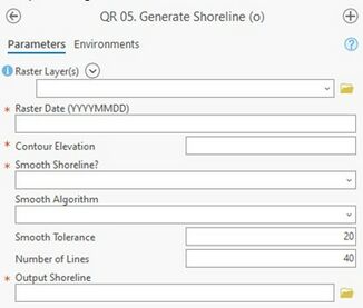
[[File:QR Step5.jpg|thumb|right|alt=A screenshot of the ArcPro geoprocessing panel for Step 5. The "Raster Layers" input allows the user to select the file from a dropdown menu or the file explorer. The "Raster Date" input is a text box which requires the input be Year, Month, then Date with no spaces or punctuation (YYYYMMDD). The "Contour Elevation" input requires the user to enter a text value (numerical). The "Smooth Shoreline" and "Smooth Algorithm" inputs allow the users to select desired options from drop down menus. The "smooth Tolerance" and "Number of Lines" inputs require the user to type numerical values. The "Output Shoreline" input allows the user to enter file locations as text or select from the file explorer.|Step 5, Generate Shoreline. Red stars indicate required fields.]] | [[File:QR Step5.jpg|thumb|right|alt=A screenshot of the ArcPro geoprocessing panel for Step 5. The "Raster Layers" input allows the user to select the file from a dropdown menu or the file explorer. The "Raster Date" input is a text box which requires the input be Year, Month, then Date with no spaces or punctuation (YYYYMMDD). The "Contour Elevation" input requires the user to enter a text value (numerical). The "Smooth Shoreline" and "Smooth Algorithm" inputs allow the users to select desired options from drop down menus. The "smooth Tolerance" and "Number of Lines" inputs require the user to type numerical values. The "Output Shoreline" input allows the user to enter file locations as text or select from the file explorer.|Step 5, Generate Shoreline. Red stars indicate required fields.|326x326px]] | ||
'''Summary:''' This tool generates shorelines from raster datasets at a user defined elevation. The shorelines generated in this step are necessary for shoreline change computation. | '''Summary:''' This tool generates shorelines from raster datasets at a user defined elevation. The shorelines generated in this step are necessary for shoreline change computation. | ||
| Line 26: | Line 26: | ||
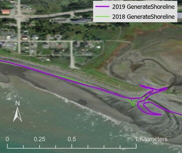
Figure 8 below displays output 2018 and 2019 shorelines for example Homer, AK data. | Figure 8 below displays output 2018 and 2019 shorelines for example Homer, AK data. | ||
[[File:QRFigure8.jpg|thumb|center|alt=A zoomed in extent of the coast that shows 2018 and 2019 shorelines in green and purple respectively. This section of coast shows an area where both shorelines cut inland towards a washed out reservoir. |Figure 8: Shoreline outputs in purple (2019) and green (2018) at Homer, AK]] | [[File:QRFigure8.jpg|thumb|center|alt=A zoomed in extent of the coast that shows 2018 and 2019 shorelines in green and purple respectively. This section of coast shows an area where both shorelines cut inland towards a washed out reservoir. |Figure 8: Shoreline outputs in purple (2019) and green (2018) at Homer, AK|363x363px]] | ||
==Useful Links== | ==Useful Links== | ||
[[JALBTCX|JALBTCX Main Documentation Page]] | [[JALBTCX|JALBTCX Main Documentation Page]] | ||
[[JALBTCX/QRReferences|Refences: Quick Response Toolbox]] | [[JALBTCX/QRReferences|Refences: Quick Response Toolbox]] | ||
Revision as of 21:51, 10 December 2024

Summary: This tool generates shorelines from raster datasets at a user defined elevation. The shorelines generated in this step are necessary for shoreline change computation.
Raster Layers: Specify one or more raster layers from where the shoreline elevation will be extracted.
Raster Date (YYYYMMDD): Date associated with the raster from the above input.
Contour Elevation: Elevation of contour to represent shoreline position (typically the MHW value for area of interest)
Smooth Shoreline: The default value is NO. Should the user require smoothing the shoreline and select YES, the algorithm and tolerance must be specified.
Smooth Algorithm: Choose between Paek and Bezier interpolation for smoothing. Documentation on both algorithms can be found within ArcGIS Pro Tool Reference resources.
Smooth Tolerance: Specify the number of units (based on the horizontal units of the raster) that are considered when smoothing the line. A larger number corresponds to a more smoothed (more linear) line.
Number of Lines: This tool creates contours for all selected Raster Layers/ Number of lines sorts the contour lines by length and selects the longest X lines. A value of “2” would select the longest two lines.
Output Shoreline: Output line feature class that represents the computed shorelines. The shapefile name and save location are user defined.
Best Practices & Example Data:
1. The shorelines from this tool may require manual editing to delete contour lines that are not shoreline data. For smoothing tolerance, a value of 20 meters is typically effective and is the default value within the tool.
Figure 8 below displays output 2018 and 2019 shorelines for example Homer, AK data.
