Model Coupling
Introduction

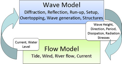
CMS-Flow and CMS-Wave can be run separately or coupled together using a process called steering. The variables passed from CMS-Wave to CMS-Flow are the significant wave height, peak wave period, wave direction, wave breaking dissipation, and radiation stress gradients. CMS-Wave uses the update bathymetry, water levels, and currents from CMS-Flow. The time interval (constant) at which CMS-Wave is run is called the steering interval. The steering process is as follows:
- 1. CMS-Wave model is run for the first two time steps (time = and time = ) and the wave information is passed to CMS-Flow.
- 2. CMS-Flow runs from time = until time = and interpolates the wave variables from during the simulation
- 3. CMS-Wave is run again for time = and
- 4. The process is repeated over until the end of the steering simulation.
Prediction of Water Levels and Currents
Because CMS-Wave requires the water surface elevation at times that are ahead of the hydrodynamics, the water surface elevation and currents. If the steering is relatively small (~<30 min), than the values from the previous time step may be used without significant error.
{{Equation }}
However, in many coastal engineering projects it is desirable and common to use relatively large steering intervals of 2-3 hours and 3 hours is especially common since many wave buoy data products are at 3 hour intervals.
This may be expressed in the following form
where is the water surface elevation and indicates the CMS-Wave time step.
In cases where the relative surface gradients at any time are much smaller than the mean tidal elevation, a better approximation of water level may be obtained by decomposing the water level into
where is the mean water level, and is the component due to tidal, wave, and wind generated surface gradients. can be estimated from water level boundary conditions and is generally much larger, so may be neglected. For some cases in which the surface gradients do not vary significantly over time (open coast beach), the second term may be approximated as
.
| Symbol | Description | Units |
|---|---|---|
| Water surface elevation | m |