CMS-Wave Model Parameters
CMS-Wave Setup
Grid Generation
Now that all modifications to the CMS-Flow grid alternatives have been finalized, the wave grid can be generated from the Flow grid. CMS-Wave grids are typically generated from scatter datasets, but can be a mirror image of the flow grid if the boundary condition (BC) locations are close enough to force both the tide and waves from the same BC area. In the near future, CMS will have the option to be run fully inline, where only one grid will contain all of the information needed to run both CMS-Wave and CMS-Flow.
The CMS-Wave IJ triad should be adjusted where the I-direction is pointing in the dominant wave direction, or more specifically from the open ocean. This means that it will be 180 deg off as compared to the CMS-Flow grid. Therefore, after the CMS-Flow grid is generated, the model domain should be set to include all major reaches of the bay, extending laterally a couple kilometers from the inlet and extending seaward well beyond the anticipated reach of the ebb jet. A good rule of thumb for setting the ocean boundary for inlet modeling is to place the boundary three or four times the length of the ebb jet (leaving provision for extreme discharges, such as during storm surge). The given bathymetry ends at approximately four times the length of the ebb jet at Shark River.

- Transforming the CMS-Flow grid to a CMS-Wave Grid
1. Open one of the generated grids rt-click the Grid in the SMS list, and click on Duplicate, select the copied grid (copy) to activate it, and go to Data, Switch Current Model (Figure 28),
2. Change the Model from CMS-Flow to CMS-Wave, click OK, and rename the grid by rt-clicking on the copy name and clicking Rename,

3. Set the jetty and groin cells to rubble-mound type structures by selecting the cells (Figure 27), and rt-click, Cell Attributes.., and select a Rubble-mound from the Structure Type, click OK.
4. File, Save As, Wave.sim (selecting the Save As Type as a .sim for simulation) in the folder with the CMS-Flow grid.
Providing Ocean Buoy Data to CMS-Wave
After all modifications to the CMS-Wave grid are complete, the spectral waves or wave parameters can be generated for the wave grid. Full (directional) spectra can be imported into the SMS for the CMS-Wave, as well as simplified wave parameters (angle, wave height, and period, etc). Directional spectral data collected by the National Data Buoy Center (NDBC) or Coastal Data Information Program (CDIP) buoys, available from the National Oceanographic Data Center, can be processed (transformed to the model domain) and used as a source for wave input to CMS-Wave.
Importing NDBC bouy data
- Run ndbc-spectra.exe to read the NDBC standard directional wave file and prepare the CMS-Wave input spectral *.eng file.
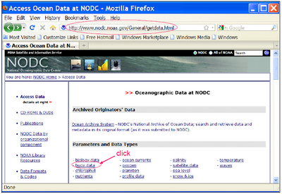
1. Download the NDBC standard monthly directional wave spectral file from http://www.nodc.noaa.gov/BUOY/buoy.html (e.g., 44025_200912) (Figures 28 to 31), this is provided under Hands On Materials - Shark River Inlet/Waves.
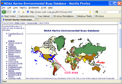
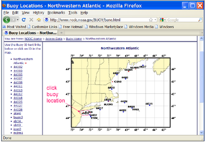
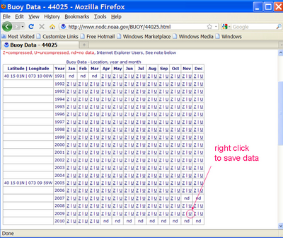
2. In the DOS mode (Command Prompt), run ndbc-spectra.exe (Figure 32),
3. Responding to the on-screen input, type the NDBC spectral filename,
4. Type the starting time stamp (default value is 0) for saving output file(s),
5. Type ending time stamp (default is 99999999) for saving output file(s),
6. Type the time interval (hr) for saving output data,
7. Type 2 to save the CMS-Wave *.eng and *.txt files,
8. Type the local shoreline orientation (actually the CMS-Wave grid y axis) in Polar Coordinates (deg, positive from North covering the sea, e.g., 180 deg for a north-south oriented project on the Atlantic coast),
9. Type the NDBC buoy location water depth (m) and then the CMS-Wave seaward boundary mean water depth (m), e.g. Buoy 44025 has a nominal depth of 36.3 m,
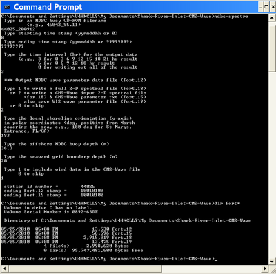
10. Type 1 to include wind or 0 to skip the wind, and to complete the run (Figure 32),
The fort.15 and fort.18 files are the parameter and spectra, respectively, to be imported in to CMS-Wave. Two additional files are generated: fort.12 and fort.19, which are the tabulated wave (and wind) parameters for the full-plane and half-plane wave propagation coverage, respectively. Matlab fig1set.m and fig2sets.m can read these files to plot the wave and wind data time series.
11. Rename fort.15 to *.txt and fort.18 to *.eng (half-plane wave energy), which was renamed to wave_shark_2009.eng,
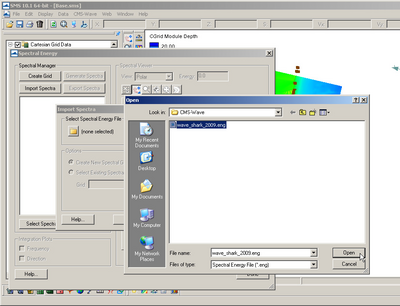
12. In SMS, go to CMS-Wave, then Spectral Energy, and select Import, and select the *.eng file just created (Figure 33),
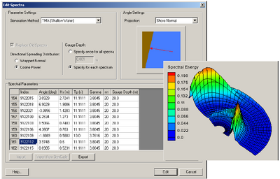
13. Save as a new CMS-Wave file (.sim) and all necessary files including the spectral energy file will be saved with that name (Figure 34).
If these steps (from pages 27-31) are skipped, there is a grid provided under Hands On Materials - Shark River Inlet/CMS-Wave that has the spectra included.
Importing CDIP buoy data
Importing CDIP buoy data is similar to the method of importing NDBC buoy data.
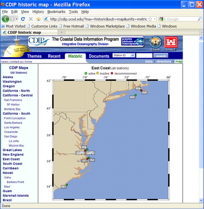
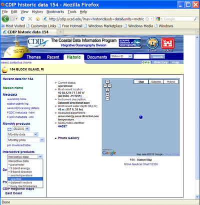
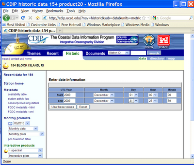
1. Download the CDIP wave file from http://cdip.ucsd.edu/?nav=historic&sub=data (e.g., sp154-200912) (Figures 35 to 37), also provided under Hands On Materials - Shark River Inlet/Waves,
Note that the only difference is the processed CDIP wave spectra do not need to be transformed to the CMS-Wave seaward boundary. The data can be directly input to CMS-Wave. Examples given are CDIP 154 and NDBC 44025 standard spectral files for Dec 2009.
2. Run cdip-spectra.exe and follow the same steps as those from pages 30-31 (from processing the NDBC buoy data with the ndbc-spectra.exe program), to read the CDIP standard directional wave file and prepare the data for input to CMS-Wave as a *.eng file.
Model Control

To setup the model parameters for CMS-Wave:
1. Go to CMS-Wave, Model Control, and turn on Allow wetting and drying and Bed friction (Figure 38),
2. Users can also specify constant or varied forward and backward reflection coefficients in Settings,
3. Water level and wind information are optional source as specified under Wave Source in addition to the spectral input data,
4. File, Save As, Wave.sim (selecting the Save As Type as