SBAS/UsersGuide
__NOTITLE__
SBAS User's Guide
Versions & Requirements
- SBAS ArcGIS Pro
- SBAS ArcGIS Desktop
- Requires ArcGIS 10.1 - 10.4
- Python comtypes package (tested with 0.6.2 - included with this tool)
- URL: https://pypi.org/project/comtypes/ -- (Previous link http://starship.python.net/crew/theller/comtypes/ no longer works)
- Author: Thomas Heller, theller@ctypes.org
- License: MIT License
- The package must be installed into the local python instance.
- Install does not require admin rights.
- Can be installed by running comtypes-0.6.2\install_comtypes.bat
- Python comtypes package (tested with 0.6.2 - included with this tool)
- Snippets.py, slightly modified code snippets file for accessing ArcObjects via Python. (Included)
- File: snippets.py -- (Previous link http://www.pierssen.com/arcgis/misc.htm no longer works)
- Author: Mark Cederholm
- License: No specific license.
- (Formerly available on http://www.pierssen.com/ and indicated "Free stuff for GIS Developers and Users!")
- Snippets.py, slightly modified code snippets file for accessing ArcObjects via Python. (Included)
- SBAS Desktop
SBAS ArcGIS Pro
Installation Instructions

- Installation for SBAS for ArcGIS Pro is as simple as unzipping the distribution file to a local drive. The zip file includes the toolbar (SBAS_2020.pyt), layer packages (*.lyrx), a settings file (SBAS_settings.txt), and a template geodatabase (SBAS.gdb).
- To launch the SBAS tools, create a new project in ArcGIS Pro. In order to access the contents of the SBAS tool, be sure to Add a Folder Connection to your project in the Catalog pane.
- The SBAS ArcGIS Pro Toolbox
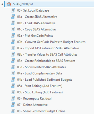
- SBAS for ArcGIS Pro is designed as an ArcToolbox written in Python. Browsing to the file SBAS_2020.pyt in the Catalog pane, will expand to show the individual tools included in the toolbox (Figure 1).
- The toolbox reads a settings file, SBAS_settings.txt, that MUST side in the the same directory as the pyt file. This file is used but the different SBAS tools to easily find the designated local SBAS database.
Local and Enterprise Data Storage
Local Database Location
SBAS uses the template database (SBAS.gdb) to storage all sediment budge geometries and alternative values. This local geodatabase contains 5 objects. The database schema follows the schema identified by SDSFIE.
- Alternative is a table that holds basic metadata information related to individual sediment budgets.
- scenarioIDPK (text, 50 characters). Primary Key. This value is auto-generated by SBAS and provides a unique identifier for each alternative (or scenario).
- sdsID (guid). This value is auto-generated by SBAS and provides a unique identifier for each alternative (or scenario). Value can be used to link to items in other enterprise GIS.
- scenarioAuthor (text, 100 characters). Author of the alternative. Name of author is pre-determined by the user login to ArcGIS Pro. Name is listed as the ArcGIS Online username.
- sdsFeatureName (text, 50 characters). Name or label of alternative.
- sdsFeatureDescription (text, 255 characters). Description of alternative.
- geoAreaDescription (text, 255 characters). Description of location of sediment budget
- projectID (text, 50 characters). Optional project id for internal management purposes. The SBAS application does not reference or write to this field.
- dateScenarioCreated (date). Data alternative created in teh SBAS database.
- budgetType (text, 50 characters). Type of sediment budget (Micro - local or Macro - regional).
- dateIntervalStart (date). Start date of alternative epoch.
- dateIntervalEnd (date). End date of alternative epoch.
- cellUnits (text, 255 characters). Units of volume for litttoral cells (Cubic Yards or Cubic Meters)
- qUnits (text, 255 characters). Units of volume for sediment transport rate (Cupic Yards/Year or Cubic Meters/Year)
- uncertaintyMethods (text, 50 characters). List of uncertainty methods used in Sediment Budget. The SBAS application does not reference or write to this field.
- medialDPK (text, 50 characters). ID to hold links to related media documentation. The SBAS application does not reference or write to this field.
- sdsMetadataID (text, 50 characters). ID to hold unique metadata ID.
- Sediment Management Cells (polygon) Boundaries of each littoral cell.
- littoralCellIDPK (text, 50 characters). Primary Key. This value is auto-generated by SBAS and provides a unique identifier for each littoral cell.
- sdsFeatureName (text, 50 characters). Name or label of the littoral cell.
- sdsFeatureDescription (text, 255 characters). Description of the littoral cell.
- scenarioIDFK (text, 50 characters). Foreign Key. Value to the related alternative (or scenario).
- removalVolume (double). Volume of sediment removal (per littoral cell and alternative).
- placementVolume (double). Volume of sediment placement (per littoral cell and alternative).
- deltaVolume (double). Change in volume per littoral cell and alternative.
- valConfidence (text, 255 characters). Determine level of data confidence, assigned by sediment budget author. Low, Medium, High
- residualVolume (double). Computed Residual volume per littoral cell and alternative.
- Residual is computed by Sum of Transport Placement - Sum of Transport Removal - delta volume + Placement volume - Removal volume.
- SBAS tools will compute the residual volume based on values assigned to SBAS features.
- SBAS determines the direction of sediment fluxes and automatically identifies each as either a "source" or "sink" for each cell.
- transportRemoval (double). Sum of transport removal per cell.
- SBAS finds all sediment fluxes where the starting point of the line intersects the littoral cell. These fluxes are classified as "sink" volumes.
- All sink volumes are summed and values reported to this field.
- transportPlacement (double).Sum of transport placement per cell.
- SBAS finds all sediment fluxes where the end point of the line (arrow head) intersects the littoral cell. These fluxes are classified as "sources" volumes.
- All source volumes are summed and values reported to this field.
- volumeUom (text, 50 characters). Units of measure for Volume Change, Removal, Placement and Residual volumes. Cubic Yards or Cubic Meters.
- transportUom (text, 50 characters). Units of measure for Sediment Transport Rates. Cubic Yards/Year or Cubic Meters/Year.
- alternativeLable (text, 255 characters). Name of Alternative
- mediaIDPK (text, 50 characters). ID to hold links to related media documentation.The SBAS application does not reference or write to this field.
- sdsMetadataID (text, 50 characters). ID to hold unique metadata ID.
- projectID (text, 50 characters). Optional project id for internal management purpose.The SBAS application does not reference or write to this field.
- sdsID (guid). This value is auto-generated by SBAS and provides a unique identifier for each alternative (or scenario). Value can be used to link to items in other enterprise GIS.
- SedimentTransportDirection (polyline) Linear representation of sediment transport.
- sedimentTransportDirectionIDPK (text, 50 characters). Primary Key. This value is auto-generated by SBAS and provides a unique identifier for each flux.
- sdsFeatureName (text, 50 characters). Name or label of the flux.
- sdsFeatureDescription (text, 255 characters). Description of the flux.
- scenarioIDFK (text, 50 characters). Foreign Key. Value to the related alternative (or scenario).
- qValue (double). Volume of sediment moving in or out of cell.
- transportUom (text, 50 characters). Units of measure for Sediment Transport Rates. Cubic Yards/Year or Cubic Meters/Year.
- alternativeLable (text, 255 characters). Name of Alternative
Enterprise Database Location
- All users of SBAS can control the accessibility of their Sediment Budgets published on the Enterprise.
- You must be signed into to ArcGIS Pro with your user id. To determine if you are logged into ArcGIS Pro, look in the upper right corner. If you are signed in you will see your account name, otherwise it will list "Not signed in".
- Click the drop-down menu, and follow the Sign-In link to log into your account (Figure 2).
- When running SBAS, if you drop a connection and are signed out you will receive an error (Figure 3). If this occurs, just sign in again and relaunch the tool.


- Publishing your completed datasets to the "enterprise"
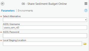
- use tool 08 - Share Sediment Budget Online. This tool will create a copy of your selected Sediment Budget Alternative and create a feature web service hosted on USACE's ArcGIS Online (AGOL) (Figure 4). Feature web services are a way geographic information is created, modified and exchanged on the Internet.
- Prepare your ArcGIS Pro project. Remove any extraneous datasets from the Table of Contents. Anything list here will be included in your webservice. Don't forget to to Save your project.

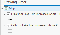
- The Table of Contents may have multiple display options for a single dataset, e.g. cell outlines and color-coded cells by residual. Only keep one visualization per dataset for your service (Figure 5). Remove all others from your table of content.

- In order to launch this tool you will need an account created for you on https://usace.maps.arcgis.com/home/index.html
- To obtain an AGO account, please contact one of the POCs listed at the bottom of this page.
- In ArcGIS Pro you must be logged in with your USACE AGO credential to correctly publish SBAS data.
- If your tool shows "No Parameters" message, this means you have been logged out of ArcGIS Online within ArcGIS Pro (Figure 6). To fix, in the upper right corner of ArcGIS Pro, click Sign-In.

- This tool will OVERWRITE any web services you own of the same name.
- Set your connection and content parameters.
- Local Staging Location is the local drive where ArcGIS ArcPro will copy temporary files needed to create your service.
- Your SBAS Service will be created for all layers within your current saved version of your ArcGIS Pro project.
- Your selected Alternative will be used to build a summary and description for your Feature Service.
- If you have more than 1 alternative loaded in your Table of Contents, all will be combined into a single feature service but as separate layers.
- a. The Feature Service description will be pulled from the alternative selected with tool 08 - Share Sediment Budget Online.
- b. All layers will be listed in your service definition.
- c. Supplemental Budget Data
- Do not publish any datasets that contain PII (Personally identifiable information), For Official Use Only (FOUO), other other sensitive information.
- Do not publish datasets that are already available online. E.g., NOAA Shorelines are available as a web service hosted by NOAA and should not be included as part of your service package.
- SBAS Budget service should include littoral cells, sediment fluxes, and optional supplemental data such as properties of bluffs.
- Feature Web Services are created for each alternative and are documented with the details you provide when the alternative is created.
- See Create SBAS Alternative section
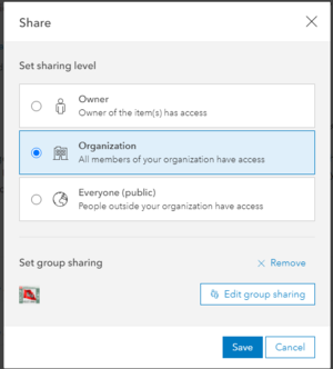
- Web Services are initially only shared to the USACE organization. To share your sediment budgets to Everyone, edit the AGO item in My Contents on https://usace.maps.arcgis.com/
- Log-in to https://usace.maps.arcgis.com/
- Browse to My Contents and locate the budget to share. Click the checkbox in front of the budget item (Figure 7).

- Click the Share link
- To share to Everyone (public) click this sharing level (Figure 8). Group level sharing can also be modified. All sediment budgets created in SBAS should be shared.

Creating a Sediment Budget
GenCade/SBAS Compatibility
SBAS ArcGIS Desktop
Installation
- Download SBASArc10 Toolbox Here
- Extract ZIP distribution
- Move SBAS directory to one's desired location
- Run SBAS\comtypes-0.6.2\install_comtypes.bat
- Run SBAS\install_dependencies.bat
- Within the Catalog, add a Folder Connection to the SBAS directory
- Within the Folder Connection to the SBAS toolbox, expand the toolbox and execute the "00 - Set Up SBAS Environment" tool.
Usage
- If you would like to specify a workspace path and/or load a basemap, run the "00 - Set Up Environment" tool before running any other tools on your map document.
- For the remainder of the workflow, tools should be executed essentially in order. For example, one must execute "01a - Create SBAS Alternative" before executing "01b - Load SBAS Alternative", which must be run before executing "02a - Convert Graphics to New Features".
Points of Contact
Main POC: Eve Eisemann
Email: Eve.Eisemann@usace.army.mil
Secondary POC: Katie Brutsche
Email: Katherine.E.Brutsche@usace.army.mil
Technical Issues: Rose Dopsovic
Email: Rose.Dopsovic@usace.army.mil