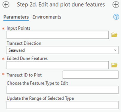
Profile Feature Extraction: Step 2d - Edit and Plot Dune Features

Summary: This step supports profile feature editing and generates an interactive plot. It moves previously extracted features (Step 2a) along individual transects for editing purposes and then generates an updated interactive plot. This step is an alternative to manual editing via the built-in ArcGIS Pro tools as previously mentioned and may be skipped if manual editing is preferred. This methodology plots the features in a profile view for editing while manual edits are typically completed in plan view.
Input Points: The points generated previously (Step 1)
Transect Direction: Indication to the toolbox which way the transect is directed based on how it was generated. Seaward indicates a transect that extends from a landward baseline towards the sea while landward indicates a transect that extends landward from a sea baseline. Use elevation attempts to detect the direction based on the slope values around the MHW point.
Edited Dune Features: The full file path, including name and file extension, of the previously generated dune features to be edited.
Transect ID to Plot: The identification value that specifies which transect will be edited and replotted.
Choose the Feature Type to Edit: A dropdown menu to select which feature on the specified transect to edit. These feature types are from the available types within the edited dune feature file specified.
Update the Range of Selected Type: A integer value specifying where along the transect the feature in question should be moved to as measured in the cross-shore from the baseline.
Best Practices:
1. The interactive plot that is generated by this tool has the capability for saving the plot but does not automatically save generated plots. Updates to the dune feature class are automatically completed. If updated plots are required, individual save actions can be completed by the user or Step 2b: Review and Re-Plot can be run to generate new plots for many transects at once.
This step allows for users to edit via a toolbox interface as compared to editing using built-in ArcGIS Pro tools, but both methodologies are acceptable.