Sargent Beach Lessons Learned
Introduction and Study Overview

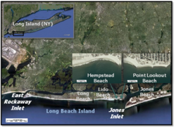
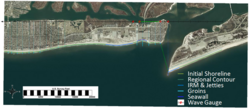
The U.S. Army Engineer District, New York, requested the Coastal Inlets Research Program (CIRP) and the Regional Sediment Management Program (RSMP) apply the shoreline change model, GenCade to Point Lookout Beach, located to the west of Jones Inlet on the south shore of Long Island, NY (Figure 1), as part of the Long Beach Island Storm Damage Reduction Project. GenCade is a new model that combines two numerical shoreline change models, the engineering detail of GENESIS (Hanson and Kraus 1989) and the long - term, regional transport processes of Cascade (Connell et al. 2007). GenCade was developed by the CIRP and the Regional Sediment Management Program. It is applied here to Point Lookout Beach to evaluate new alternatives involving local structures in the framework of a large - scale sediment management plan that includes the inlet and adjacent beaches.
