CMS-Flow:Tech Report 3
__notitle__
Coastal Modeling System
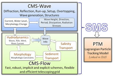
Introduction The Coastal Modeling System (CMS) is an integrated numerical modeling system for simulating nearshore waves, currents, water levels, sediment transport, and morphology change (Militello et al. 2004; Buttolph et al. 2006a; Lin et al. 2008; Reed et al. 2011). The system is designed for coastal inlets and navigation applications including channel performance and sediment exchange between inlets and adjacent beaches. Modeling provides planners and engineers essential information for improving the usage of USACE Operation and Maintenance Funds. CIRP is developing, testing, improving and transferring the CMS to Corps Districts and industry and assisting users in engineering studies. The overall framework of the CMS and its components are presented in Figure 1.
