CMS-Flow Coordinate System: Difference between revisions
Jump to navigation
Jump to search
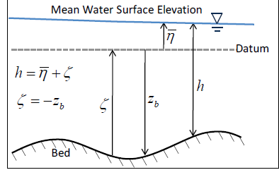 Figure 2-1. Vertical conventions used for the bed and mean water surface elevation.
(Created page with "==Coordinate System== Before presenting the depth-integrated and wave-averaged governing equations, it is useful to define the coordinate system and basic variables. Variable...") |
No edit summary |
||
| Line 2: | Line 2: | ||
Before presenting the depth-integrated and wave-averaged governing equations, it is useful to define the coordinate system and basic variables. Variables are defined spatially in a Cartesian coordinate system <math>x_i = \overrightarrow{x} = (x,y,z) </math>, where ''x'' and ''y'' are the horizontal coordinates, and ''z'' is the vertical coordinate (positive is upwards). A schematic of several of the main variables in the vertical direction is provided in Figure 2-1. The vertical coordinate datum is usually the Still Water Level (SWL). The bed elevation ''(z<sub>b</sub>)'' is measured from the vertical datum (i.e., negative downwards). | Before presenting the depth-integrated and wave-averaged governing equations, it is useful to define the coordinate system and basic variables. Variables are defined spatially in a Cartesian coordinate system <math>x_i = \overrightarrow{x} = (x,y,z) </math>, where ''x'' and ''y'' are the horizontal coordinates, and ''z'' is the vertical coordinate (positive is upwards). A schematic of several of the main variables in the vertical direction is provided in Figure 2-1. The vertical coordinate datum is usually the Still Water Level (SWL). The bed elevation ''(z<sub>b</sub>)'' is measured from the vertical datum (i.e., negative downwards). | ||
<center>[[File:fig_2_1.bmp]] | |||
Figure 2-1. Vertical conventions used for the bed and mean water surface elevation.</center> | |||
Revision as of 17:08, 11 August 2014
Coordinate System
Before presenting the depth-integrated and wave-averaged governing equations, it is useful to define the coordinate system and basic variables. Variables are defined spatially in a Cartesian coordinate system , where x and y are the horizontal coordinates, and z is the vertical coordinate (positive is upwards). A schematic of several of the main variables in the vertical direction is provided in Figure 2-1. The vertical coordinate datum is usually the Still Water Level (SWL). The bed elevation (zb) is measured from the vertical datum (i.e., negative downwards).

 Figure 2-1. Vertical conventions used for the bed and mean water surface elevation.