Publications:Newsletters/Oct2014
__NOTITLE__ CIRP April 2014 eNewsletter
Issue 35, October 2014
In this Newsletter:
CIRP FY15 Webinar #1, Friday 24 Oct 2014, 10-11 CENTRAL
CIRP FY15 Webinar #1, Friday 24 Oct, 10-11 CENTRAL – CIRP will be hosting several webinars this FY (see last paragraph, below) and our first Webinar will be held on Inlet Breaching R&D (addressing Statement of Need SoN 2014-N-14) on Friday, 24 Oct, 10-11 am CENTRAL. If you are interested in participating, please email Julie Rosati and she will forward the invite. We envision a 30-min presentation followed by (or interspersed with) 30 min discussion. Additional webinars will have separate invites as follows: Webinar #2 - AISAP (AIS analysis package) and CPT (Channel Portfolio Tool)/CSMART (Coastal Structure Management and Ranking Tool) Tools and plans (tentatively 11 Nov 2014, 1 pm CENTRAL); Webinar #3 - CMS (Coastal Modeling System) and sediment transport R&D (TBD); Webinar #4 - “Long-term morphology change at inlets and SLR R&D (TBD);” Webinar #5 – “Dune design and recovery R&D” (tentatively 21 Jan 2015, 1 pm CENTRAL); Webinar #6 – “Berm R&D in CIRP” (TBD); Webinar #7 - “WaveNet/TideNet” (tentatively Mar-May 2015).
POC: (ERDC) Julie Rosati, Julie.D.Rosati@usace.army.mil
CIRP Researchers Invade South Texas
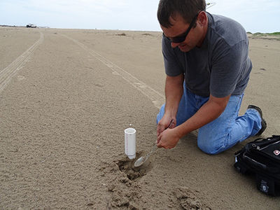
CIRP researchers descended on South Padre Island, Texas for an intensive field data collection effort in support of navigation research for Brazos Harbor Inlet (BHI) and Gulf Intercoastal Waterway (GIWW). The project aims to better understand shoaling processes within the inlet navigation channel and sediment sharing with the adjacent shorelines. Historical information suggests the inlet is shoaling at an accelerated rate and these measurements will help determine the mechanisms influencing shoaling including sediment transport pathways and deposition rates. Researchers collected 60 sediment samples in Laguna Madre and the adjacent beaches and deployed four long-term tide gauges and two bottom mounted acoustic current and wave sensors. The instruments will be deployed for one year to capture seasonal variations in wave, water, and wind conditions and this information will be used to calibrate state-of-the-art numerical models to quantify sediment transport patterns. Repeat bathymetric surveys will be conducted to generate time history maps of bed elevation changes, to be correlated with wave and current climatology for the region. In addition, ship surveys measuring full water column currents, sediment concentration profiles, salinity, and temperature at fixed stations will provide critical information on how tidal variation affects the hydrodynamics of Laguna Madre and BHI.
POC: (ERDC) Richard Styles, Richard.Styles@usace.army.mil
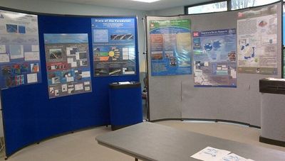
The 2014 Navigation Research Area Review Group (RARG) Meeting was conducted from 1-3 April, 2014, in Vicksburg, MS. The CIRP presentation of 2014 R&D can be downloaded from the CIRP website under "Tech Transfer -> Meetings -> RARG2014." The RARG annually reviews research efforts and prioritizes statements of need (SoNs) submitted by non-ERDC USACE personnel through the Navigation Gateway (http://operations.usace.army.mil/navigation.cfm). Navigation RD&T program managers presented their work to date in an overview of the past year and identified work planned for this year and next. Fourteen SoNs submitted in the past year were presented and discussed, and previously unfunded SoNs were reviewed. The RARG had several technology transfer demonstrations during the first and second afternoons. CIRP's demonstration of WaveNet was given by Drs. Zeki Demirbilek and Derek Wilson, and the Automated Information System Analysis Package, AISAP, was demoed by Dr. Kenneth Ned Mitchell. At the end of the meeting, the RARG ranked the cumulative list of SoNs to identify priorities for new work to begin in FY15 (rankings to be announced).
POC: (ERDC) Julie Rosati, Julie.D.Rosati@usace.army.mil
Kikiaola Harbor, HI Infrastructure Modifications Study
The Honolulu District (POH) and ERDC are evaluating alternatives to improve navigation in the entrance and interior of the Kikiaola Light Draft Harbor (KLDH), a small boat harbor located on the southwest coast of Kauai Island, Hawaii. The study includes field data collection and monitoring, and numerical wave modeling for evaluation of the structural alternatives for federal modification of KLDH. The entrance and interior of KLDH is affected by high-energy northwest swells, southern swells and storms transforming over a wide shallow reef, causing unfavorable navigation conditions for boats using this harbor. A six-month field data collection study provided wave data for calibration of numerical models at five gauges, two outside and three inside the harbor. Detailed surveys of bathymetry and structures were conducted to obtain data for numerical modeling. BOUSS-2D and CMS-Wave models were used in this infrastructure modifications modeling study, and evaluation and ranking of the eight alternatives for reducing waves in the interior harbor and entrance and access channel. The study has been completed, and final draft report is being evaluated by POH.
POC: (ERDC) Zeki Demirbilek, Zeki.Demirbilek@usace.army.mil
POC: (ERDC) Lihwa Lin, Lihwa.Lin@usace.army.mil
POC: (ERDC) William Butler, William.Butler@usace.army.mil
POC: (ERDC) Kent Hathaway, Kent.K.Hathaway@usace.army.mil
POC: (POH) Tom Smith, Thomas.D.Smith@usace.army.mil
POC: (POH) Jessica Podoski, Jessica.H.Podoski@usace.army.mil
Wave, Hydrodynamic & Morphologic Modeling in Support of the Lateral Expansion of Poplar Island, MD
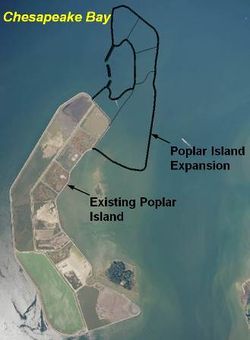
CIRP and the Baltimore District (NAB) are conducting a wave, hydrodynamic, and particle tracking modeling study in support of the Baltimore District’s design analysis for the lateral expansion of Poplar Island. The island expansion implements the use of an embayment, which must be optimized to minimize sedimentation and reduce the wave climate, and results in a technically sound design for a series of dike/breakwaters across the mouth of embayment. This study will include determining the hydrodynamic, wave, and wind forcing conditions, and modeling different breakwater alternatives to examine sediment dynamics, wave climate and hydrodynamic regimes within the embayment for each alternative. The CIRP will run ADCIRC and CMS to obtain regional scale wind and waves. The CMS/PTM will be used to calculate wave height/energy, flow, and particle movement for the alternatives. The final results will show changes in waves and current within the embayment and sediment particle behavior corresponding to different dike/breakwater configurations, and will determine the most favorable alternative.
POC: (ERDC) Honghai Li, Honghai.Li@usace.army.mil
POC: (ERDC) Tanya Beck, Tanya.M.Beck@usace.army.mil
POC: (ERDC) Mitchell Brown, Mitchell.E.Brown@usace.army.mil
POC: (NAB) Tom Laczo, Thomas.D.Laczo@usace.army.mil
POC: (NAB) Tom Myrah, Thomas.P.Myrah@usace.army.mil
Change in Newsletter Frequency
Our eNewsletter is transitioning to bi-annual eNewletters. We will provide updates on CIRP R&D each April and October, immediately after our annual RARG and at the start of the Fiscal Year. However, we always invite input from inlet interests!
POC: (ERDC) Julie Rosati, Julie.D.Rosati@usace.army.mil
Engineer Research & Development Center
3909 Halls Ferry Road, Coastal & Hydraulics Laboratory
Vicksburg, MS 39180
251-635-9519


