SAJ-Sarasota County: Difference between revisions
No edit summary |
No edit summary |
||
| Line 3: | Line 3: | ||
<font color=red>'''UNDER CONSTRUCTION'''</font> | <font color=red>'''UNDER CONSTRUCTION'''</font> | ||
'''INTRODUCTION''' | |||
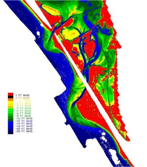
[[Image:SAJ_BSPNP5.png|thumb|right|300px|Figure 1. Lidar bathymetry, May 2006, for New Pass and Big Sarasota Pass, Sarasota County, Florida.]] | |||
The Jacksonville District (SAJ) was directed to conduct a regional sediment study of a section of the Sarasota County, Florida Gulf Coast shoreline that encompasses New Pass and Big Sarasota Pass and the adjacent beaches (Figure 1) to develop an in-depth understanding of wave-forced and tidally-forced sediment transport processes and to configure an analytical model of the two-inlet system that includes regional sediment sources, sinks, and pathways that could be used for evaluating engineering and management alternatives. This effort was funded by the RSM program and focuses on the CMS-M2D morphological modeling of the Big Sarasota Pass and New Pass inlet system. Qualitative and Quantitative comparisons of CMS-M2D and LIDAR derived bathymetric changes were conducted, for the period of May to November 2004, to demonstrate the ability of CMS-M2D to simulate the morphology of the area. | The Jacksonville District (SAJ) was directed to conduct a regional sediment study of a section of the Sarasota County, Florida Gulf Coast shoreline that encompasses New Pass and Big Sarasota Pass and the adjacent beaches (Figure 1) to develop an in-depth understanding of wave-forced and tidally-forced sediment transport processes and to configure an analytical model of the two-inlet system that includes regional sediment sources, sinks, and pathways that could be used for evaluating engineering and management alternatives. This effort was funded by the RSM program and focuses on the CMS-M2D morphological modeling of the Big Sarasota Pass and New Pass inlet system. Qualitative and Quantitative comparisons of CMS-M2D and LIDAR derived bathymetric changes were conducted, for the period of May to November 2004, to demonstrate the ability of CMS-M2D to simulate the morphology of the area. | ||
'''BATHMETRY DATA''' | |||
LIDAR bathymetry from May 2004, shown in Figure 1, illustrates the morphological features of Big Sarasota Pass. The main channel, with a depth of up to 8.0 m, runs between the ebb shoal and Siesta Key. The ebb shoal, between 0 and 2.0 m depth, has one larger flood channel about mid-way along it’s length and 3 or 4 smaller flood channels adjacent to Lido Key. Bypassing at the southern end of the ebb shoal to Siesta Key is also evident. LIDAR bathymetry from May 2006, shown in Figure 4, illustrates very similar morphological features but the ebb shoal now has two large flood channels. | |||
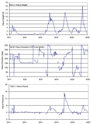
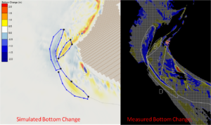
Observed bathymetric changes, from the differences between LIDAR surveys from May 2004, November 2004, and May 2006, are shown in Figure 5. For the period May to November 2004, erosion and accretion in Area I, is evidence of alongshore shore transport along Lido Key. The erosion in Area A, at the distal portion of the ebb shoal, is due primarily to the wave induced transport during the three hurricanes in September 2004. Much of this material moves south to Area D. Wave induced transport also moves some of this material along the ebb shoal toward the Northeast. Area K shows evidence of bypassed material working its way down drift and shoreward to Siesta Key. Area E shows one bar attached to the Siesta Key shoreline. Many of the same morphological patterns are evident during May 2004 to May 2006, shown in the left | |||
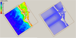
[[Image:SAJ_BSPNP4.png|thumb|right|300px|Figure 1. New Pass and Big Sarasota Pass, Sarasota County, Florida.]] | [[Image:SAJ_BSPNP4.png|thumb|right|300px|Figure 1. New Pass and Big Sarasota Pass, Sarasota County, Florida.]] | ||
Revision as of 21:07, 8 December 2010
UNDER CONSTRUCTION
INTRODUCTION
The Jacksonville District (SAJ) was directed to conduct a regional sediment study of a section of the Sarasota County, Florida Gulf Coast shoreline that encompasses New Pass and Big Sarasota Pass and the adjacent beaches (Figure 1) to develop an in-depth understanding of wave-forced and tidally-forced sediment transport processes and to configure an analytical model of the two-inlet system that includes regional sediment sources, sinks, and pathways that could be used for evaluating engineering and management alternatives. This effort was funded by the RSM program and focuses on the CMS-M2D morphological modeling of the Big Sarasota Pass and New Pass inlet system. Qualitative and Quantitative comparisons of CMS-M2D and LIDAR derived bathymetric changes were conducted, for the period of May to November 2004, to demonstrate the ability of CMS-M2D to simulate the morphology of the area.
BATHMETRY DATA
LIDAR bathymetry from May 2004, shown in Figure 1, illustrates the morphological features of Big Sarasota Pass. The main channel, with a depth of up to 8.0 m, runs between the ebb shoal and Siesta Key. The ebb shoal, between 0 and 2.0 m depth, has one larger flood channel about mid-way along it’s length and 3 or 4 smaller flood channels adjacent to Lido Key. Bypassing at the southern end of the ebb shoal to Siesta Key is also evident. LIDAR bathymetry from May 2006, shown in Figure 4, illustrates very similar morphological features but the ebb shoal now has two large flood channels. Observed bathymetric changes, from the differences between LIDAR surveys from May 2004, November 2004, and May 2006, are shown in Figure 5. For the period May to November 2004, erosion and accretion in Area I, is evidence of alongshore shore transport along Lido Key. The erosion in Area A, at the distal portion of the ebb shoal, is due primarily to the wave induced transport during the three hurricanes in September 2004. Much of this material moves south to Area D. Wave induced transport also moves some of this material along the ebb shoal toward the Northeast. Area K shows evidence of bypassed material working its way down drift and shoreward to Siesta Key. Area E shows one bar attached to the Siesta Key shoreline. Many of the same morphological patterns are evident during May 2004 to May 2006, shown in the left
