User Guide 029: Difference between revisions
Jump to navigation
Jump to search
(Created page with "19 Appendix I: UTM and State Plane Zones The main purpose of the State Plane coordinate system was to designe a conformal mapping system which minizes local distortion to less...") |
No edit summary |
||
| Line 1: | Line 1: | ||
19 Appendix I: UTM and State Plane Zones | =19 Appendix I: UTM and State Plane Zones= | ||
The main purpose of the State Plane coordinate system was to designe a conformal mapping system which minizes local distortion to less than 1/10,000. In order to achieve this accuracy, some states were divided into smaller zones called FIPS (Federal Information Processing Standard) zone. The table below lists the US zone names FIPS zone numbers, and UTM zones | The main purpose of the State Plane coordinate system was to designe a conformal mapping system which minizes local distortion to less than 1/10,000. In order to achieve this accuracy, some states were divided into smaller zones called FIPS (Federal Information Processing Standard) zone. The table below lists the US zone names FIPS zone numbers, and UTM zones | ||
| Line 6: | Line 7: | ||
A description of the State Plane zones including maps can be viewed at http://www.ems-i.com/smshelp/General_Tools/Coordinates/StatePlane_system.htm. | A description of the State Plane zones including maps can be viewed at http://www.ems-i.com/smshelp/General_Tools/Coordinates/StatePlane_system.htm. | ||
[[File:fig_19-1.png]] | |||
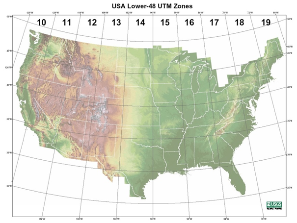
Figure 19-1. UTM zones for the Lower 48 states (from USGS). | |||
Revision as of 15:51, 4 May 2015
19 Appendix I: UTM and State Plane Zones
The main purpose of the State Plane coordinate system was to designe a conformal mapping system which minizes local distortion to less than 1/10,000. In order to achieve this accuracy, some states were divided into smaller zones called FIPS (Federal Information Processing Standard) zone. The table below lists the US zone names FIPS zone numbers, and UTM zones
mulipage table
A description of the State Plane zones including maps can be viewed at http://www.ems-i.com/smshelp/General_Tools/Coordinates/StatePlane_system.htm.
Figure 19-1. UTM zones for the Lower 48 states (from USGS).
