JALBTCX/QRStep10: Difference between revisions
Created page with "{{DISPLAYTITLE:Quick Response Toolbox: Step 10 - Generate Change Table}} File:QR Step10.jpg|thumb|right|alt=A screenshot of the ArcPro geoprocessing panel for Step 10. The "Transects", "Difference Volume Table", "Difference Volume Above Shoreline", and "Shoreline Change" inputs allow the user to select the files from a dropdown menu or the file explorer. The "Change Table" allows the user to enter the desired file location as a text path or select from the file explor..." |
mNo edit summary |
||
| Line 1: | Line 1: | ||
{{DISPLAYTITLE:Quick Response Toolbox: Step 10 - Generate Change Table}} | {{DISPLAYTITLE:Quick Response Toolbox: Step 10 - Generate Change Table}} | ||
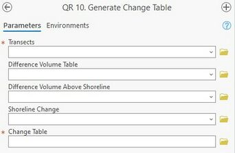
[[File:QR Step10.jpg|thumb|right|alt=A screenshot of the ArcPro geoprocessing panel for Step 10. The "Transects", "Difference Volume Table", "Difference Volume Above Shoreline", and "Shoreline Change" inputs allow the user to select the files from a dropdown menu or the file explorer. The "Change Table" allows the user to enter the desired file location as a text path or select from the file explorer.|Step 10: Generate Change Table]] | [[File:QR Step10.jpg|thumb|right|alt=A screenshot of the ArcPro geoprocessing panel for Step 10. The "Transects", "Difference Volume Table", "Difference Volume Above Shoreline", and "Shoreline Change" inputs allow the user to select the files from a dropdown menu or the file explorer. The "Change Table" allows the user to enter the desired file location as a text path or select from the file explorer.|Step 10: Generate Change Table|342x342px]] | ||
'''Summary:''' This tool combines the information developed in Step 1 through Step 9 into a single table for future querying. It does not require every step be run and entered only those applicable to the user’s interests. | '''Summary:''' This tool combines the information developed in Step 1 through Step 9 into a single table for future querying. It does not require every step be run and entered only those applicable to the user’s interests. | ||
Revision as of 20:23, 11 December 2024

Summary: This tool combines the information developed in Step 1 through Step 9 into a single table for future querying. It does not require every step be run and entered only those applicable to the user’s interests.
Transects: Transects created in Step 1.
Difference Volume Table: Difference Volume table generated in Step 4.
Difference Volume Above Shoreline: Difference volume above shoreline generated in Step 8.
Shoreline Change: Shoreline change generated in Step 9.
Change Table: Specify the name and location for the output change table.
Output Change Table: This is a table within ArcGIS that contains attributes from the Volume Change, Shoreline Change, and MHW Volume Change tables. The output filename and location are user defined.