SMS: Difference between revisions
mNo edit summary |
|||
| Line 30: | Line 30: | ||
Below are pictures of the updated card in the .cmcards as well as a few lines from the .spcards file. | Below are pictures of the updated card in the .cmcards as well as a few lines from the .spcards file. | ||
<gallery> | |||
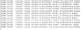
SMS_SavePts_cmcards.png|New card for this output. | |||
SMS_SavePts_spcards.png|Example of the cards written. | |||
</gallery> | |||
== CMS Executable == | == CMS Executable == | ||
Revision as of 18:43, 21 January 2025
What Is SMS?
SMS (Surface-water Modeling System) is a complete program for building and simulating surface water models. It is a graphical user interface and analysis tool that allows engineers and scientists to visualize, manipulate, analyze, and understand numerical data and associated measurements. Many of the tools in SMS are generic. They are designed to facilitate the establishment and operation of numerical models of rivers, coasts, inlets, bays, estuaries, and lakes. It features 1D and 2D modeling and a unique conceptual model approach. Some of the currently supported models in SMS include ADCIRC, BOUSS-2D, CGWAVE, CMS-Flow, CMS-Wave, GenCade, SRH-2D, STWAVE, and TUFLOW.
Introduction to SMS
- The Highlights provide a summary of SMS capabilities.
- The SMS tutorials are step-by-step guides for building models and using SMS features. They are an excellent place to begin learning how to use SMS.
- See Layout of the Graphical Interface for more information on the organization of the toolbars, menus, and windows in SMS.
- Much of the SMS functionality is divided into modules based upon the type of data (grids, meshes, GIS, etc). SMS also contains features that are not tied to specific modules.
- SMS supports a number of numerical models with a variety of uses including hydraulics, wave modeling, and particle tracking.
History
SMS was initially developed by the Engineering Computer Graphics Laboratory (later renamed in September, 1998 to Environmental Modeling Research Laboratory or EMRL) at Brigham Young University in the late 1980s on Unix workstations. The development of SMS was funded primarily by The United States Army Corps of Engineers. It was later ported to Microsoft Windows platforms in the mid 1990s and support for HP-UX, IRIX, DEC-OSF, and Solaris platforms was discontinued.
In April 2007, the main software development team at EMRL entered private enterprise as Aquaveo LLC and continue to develop SMS and other software products, such as WMS (Watershed Modeling System) and GMS (Groundwater Modeling System).
See the Aquaveo SMS Wiki for more information.
CMS-Flow Hard Bottom Dataset
Between SMS 12.0 and SMS 13.3, if the user wished to enter cell-specific values for hard bottom to the grid, they had to do it manually. Oftentimes, this led to misaligned hard bottom datasets, especially for cells which were to be deemed unerodable (such as for jetties and other structures).
SMS 13.4 has been modified to allow for a better user experience when generating hard bottom datasets. See the new CMS Hard Bottom page on this wiki for more information and guidance.
CMS-Flow Structures
A few pages have been added to this wiki to explain the various CMS-Flow structures.
These pages can be found here.
CMS-Flow Save points
SMS now populates a new file (.spcards) when there are more than 10 save points present. Previously all lines were written directly to the CMS-Flow parameter file (.cmcards); however, when there was a large number of points the file could be very long. By writing all the points to a new file when there are 10 or more points, this makes the parameter file easier to read.
Below are pictures of the updated card in the .cmcards as well as a few lines from the .spcards file.
-
 New card for this output.
 -
 Example of the cards written.
CMS Executable
Some of the new features as outlined above (Structures, Save Points) are available only with the 5.4.0 version of CMS and above. The obtain this version, see the CMS_Releases page on this wiki.
Bug fixes
- SMS now properly writes out all necessary cards regardless of grid angle.
- SMS now properly writes Latitude and Longitude information when SMS Projections are selected.
- SMS now properly writes the necessary cards when using an external ADCIRC Tidal Database as a boundary condition. Previously, the velocity components were ignored.
- The CMS-Flow Advanced card dialog has been simplified and now allows for only individual cards and does not attempt to place within a block.
Back to CMS
Back to CIRP Products