JALBTCX/QRStep5: Difference between revisions
mNo edit summary |
mNo edit summary |
||
| Line 27: | Line 27: | ||
[[File:QRFigure8.jpg|thumb|center|alt=A zoomed in extent of the coast that shows 2018 and 2019 shorelines in green and purple respectively. This section of coast shows an area where both shorelines cut inland towards a washed out reservoir. |Figure 8: Shoreline outputs in purple (2019) and green (2018) at Homer, AK|363x363px]] | [[File:QRFigure8.jpg|thumb|center|alt=A zoomed in extent of the coast that shows 2018 and 2019 shorelines in green and purple respectively. This section of coast shows an area where both shorelines cut inland towards a washed out reservoir. |Figure 8: Shoreline outputs in purple (2019) and green (2018) at Homer, AK|363x363px]] | ||
<center>[[JALBTCX/QRStep4|[Previous Step]]] [[JALBTCX/QRStep6|[Next Step]]]</center> | |||
==Useful Links== | ==Useful Links== | ||
[[JALBTCX|JALBTCX Main Documentation Page]] | [[JALBTCX|JALBTCX Main Documentation Page]] | ||
[[JALBTCX/QRReferences|Refences: Quick Response Toolbox]] | [[JALBTCX/QRReferences|Refences: Quick Response Toolbox]] | ||
Latest revision as of 13:56, 20 August 2025

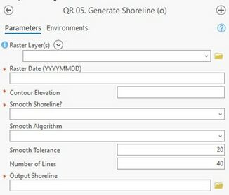
Summary: This tool generates shorelines from raster datasets at a user defined elevation. The shorelines generated in this step are necessary for shoreline change computation.
Raster Layers: Specify one or more raster layers from where the shoreline elevation will be extracted.
Raster Date (YYYYMMDD): Date associated with the raster from the above input.
Contour Elevation: Elevation of contour to represent shoreline position (typically the MHW value for area of interest)
Smooth Shoreline: The default value is NO. Should the user require smoothing the shoreline and select YES, the algorithm and tolerance must be specified.
Smooth Algorithm: Choose between Paek and Bezier interpolation for smoothing. Documentation on both algorithms can be found within ArcGIS Pro Tool Reference resources.
Smooth Tolerance: Specify the number of units (based on the horizontal units of the raster) that are considered when smoothing the line. A larger number corresponds to a more smoothed (more linear) line.
Number of Lines: This tool creates contours for all selected Raster Layers/ Number of lines sorts the contour lines by length and selects the longest X lines. A value of “2” would select the longest two lines.
Output Shoreline: Output line feature class that represents the computed shorelines. The shapefile name and save location are user defined.
Best Practices & Example Data:
1. The shorelines from this tool may require manual editing to delete contour lines that are not shoreline data. For smoothing tolerance, a value of 20 meters is typically effective and is the default value within the tool.
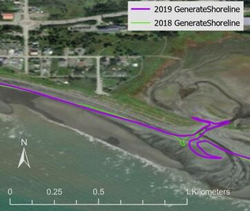
Figure 8 below displays output 2018 and 2019 shorelines for example Homer, AK data.
