CMS-Flow:Telescoping
Under Construction
Introduction
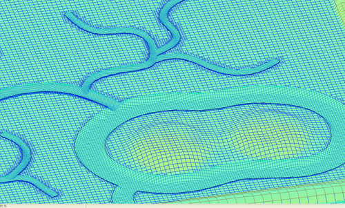
The current CMS computational grid is a non-uniform Cartesian grid which is very easy to setup and offers some degree of refinement. In order to improve the refinement capability, a telescoping mesh will be introduced in SMS 11.0. The telescoping mesh, also referred to as quadtree mesh offers local mesh refinement for the least amount of effort (both computationally and grid generation). Local refinement is achieved by subdividing a rectangular cells into 4 cells. The quadtree mesh can be arranged as block-structured or completely unstructured. In this case it has been arranged as unstructured because it offers the most flexibility. Rectangular (or quadrilateral) meshes are more convenient for establishing high-order schemes and discretizing higher order spatial derivatives. The telescoping mesh offers most of the flexibility of the triangular unstructured mesh with the computational simplicity of the rectangular mesh.
Examples of Telescoping Grids


Simplified Instructions for creation using SMS 11.0 (only available developmental [pre-beta] state presently)
Instead of adding resolution with refine points, building a telescoping grid uses polygons. The idea is to define areas that need extra resolution inside connected feature arcs. Once the arcs have been created, then convert the arcs over to polygons (Feature | Build Polygons). Once built, the polygons can be selected and their attributes changed to reflect the desired telescoped cell size. See below.
- These examples start with only a loaded bathymetry dataset and a map coverage set with the type = CMS-Flow.
- There are only a few steps that are needed to create a telescoping grid. Creation of the feature arcs and polygons is the most important and the user may need to iterate modifying the conceptual model and building the telescoping grid, until the desired grid has been created.
1. Build Conceptual Model within the SMS Map Module (version 11.0)
- a. Build Grid Frame from CMS-Flow coverage- animation
- b. Create a series of feature arcs to define the zones of increased resolution either manually or automatically
- c. Convert Feature Arcs to Feature Polygons to assign resolution values - animation
2. Generate Telescoping grid from Conceptual Model - animation
3. Go back to Step 1, if needed.

Contact Information
Alejandro Sanchez, Office: 601-634-2027, Alejandro.Sanchez@usace.army.mil