GenCade:Basic Governing Equations: Difference between revisions
No edit summary |
No edit summary |
||
| Line 1: | Line 1: | ||
{{DISPLAYTITLE:GenCade Basic Governing Equations}} | {{DISPLAYTITLE:GenCade Basic Governing Equations}} | ||
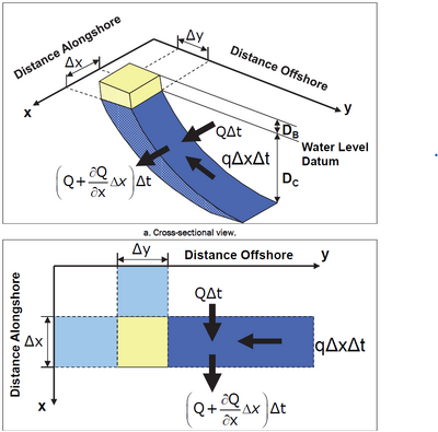
[[File:Shoreline_Change_Calculation.png|400px|thumb|right|Figure 1. The definition sketch showing a cross sectional view and a plan view of a ''dx'' ''dy'' segment of the shoreline with boundary conditions.]] | [[File:Shoreline_Change_Calculation.png|400px|thumb|right|Figure 1. The definition sketch showing a cross sectional view and a plan view of a ''dx'' ''dy'' segment of the shoreline with boundary conditions.]] | ||
The governing equation of GenCade is primarily formed by | The governing equation of GenCade is primarily formed by conservation of sand volume. The assumption is that the beach profile translates seaward or shoreward along a section of coast without changing shape. During an interval of time (Δ''t''), a net amount of sand enters or leaves the section. The change in shoreline position is Δ''y'', the length of the shoreline segment is Δ''x'', and the profile moves within a vertical extent defined by the berm elevation ''D<sub>B</sub>'' and the closure depth ''D<sub>C</sub>'', both measured from the vertical datum (for example, MSL or MLLW). | ||
The resulting change in volume along the four sides of the area is therefore calculated as: | The resulting change in volume along the four sides of the area is therefore calculated as: | ||
| Line 10: | Line 10: | ||
A definition sketch is shown in Figure 1. | A definition sketch is shown in Figure 1. | ||
If there is a difference between the | If there is a difference between the updrift and downdrift longshore sediment transport (''Q'', in m<sup>3</sup>/second), then the volume either expands or contracts shifting the shoreline seaward or shoreward, respectively. The contribution from a line source or sink is included as the term ''q'', where ''q'' is the sum of the addition or removal of sand per unit width of beach from either the shoreward or offshore sides. Thus: | ||
<!--'''ΔV = ΔxΔy(D<sub>B</sub>+D<sub>C</sub>) = (ΔQ/Δx)ΔxΔt +qΔxΔt'''--> | <!--'''ΔV = ΔxΔy(D<sub>B</sub>+D<sub>C</sub>) = (ΔQ/Δx)ΔxΔt +qΔxΔt'''--> | ||
Revision as of 19:48, 6 February 2023
The governing equation of GenCade is primarily formed by conservation of sand volume. The assumption is that the beach profile translates seaward or shoreward along a section of coast without changing shape. During an interval of time (Δt), a net amount of sand enters or leaves the section. The change in shoreline position is Δy, the length of the shoreline segment is Δx, and the profile moves within a vertical extent defined by the berm elevation DB and the closure depth DC, both measured from the vertical datum (for example, MSL or MLLW).
The resulting change in volume along the four sides of the area is therefore calculated as:
A definition sketch is shown in Figure 1.
If there is a difference between the updrift and downdrift longshore sediment transport (Q, in m3/second), then the volume either expands or contracts shifting the shoreline seaward or shoreward, respectively. The contribution from a line source or sink is included as the term q, where q is the sum of the addition or removal of sand per unit width of beach from either the shoreward or offshore sides. Thus:
As Δt goes to zero, a differential equation is produced that is the governing equation for the rate of change of the shoreline position:
This equation is solved with the inputs of boundary conditions and values for Q, q, DB and DC given.


