AeoLiS
This page is currently under development as the feature is being implemented.
AeoLiS is a process-based model for simulating aeolian sediment transport in situations where supply-limiting factors are important, like in coastal environments. Supply-limitations currently supported are soil moisture contents, sediment sorting and armoring, bed slope effects, air humidity and roughness elements.
This document describe the GUI development as part of the Surface-water Modeling System. Additional documentation on the model itself can be found from the following links:
Background
In FY2024, the USACE Coastal Inlets Research Program (CIRP) provided funding to implement the ability to create and store Aeolis simulations from within SMS 13.4+.
Presently (April 2025), the following components for this interface have been implemented and are being tested:
- Grid Creation
- Boundary Conditions
- Simulation
- Model Control
Interface
Grid Creation
A 2D grid for Aeolis can be created by the user. The steps for this process are given below:
- Ensure a Display Projection has been assigned for the project location.
- Add a "CGrid Generator" coverage to the "Map Data" section of the project explorer.
- Using the added coverage, generate a 2d grid frame for the correct area. Refine points can be used to increase refinement in desired locations.
- Once the grid frame is complete, right click the coverage and choose "Convert | Map -> 2d Grid" making any choices regarding bathymetry and resolution from the dialog that appears.
- Once generated, the resulting grid must then be converted to a restricted UGrid by right clicking on the Cartesian grid and choosing "Convert | 2d Grid -> Cartesian UGrid". It is this grid that will be used for Aeolis.
- The original CGrid may be deleted from the project, if desired, as it is no longer needed.
Boundary Conditions

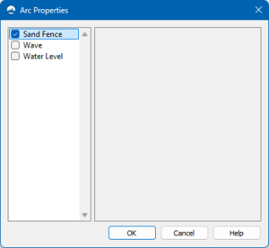
SMS uses a coverage from within the Map Module to implement the various boundary conditions. The coverage is named "AeoLiS: Boundary Conditions" through the use of Feature Arcs. Once a feature arc is placed in the appropriate location, the Arc attributes menu will allow for selection of the type. This dialog is shown in Figure 1.
The available boundary conditions are:
- Sand Fence
- Wave (TODO)
- Water Level (TODO)
Simulation

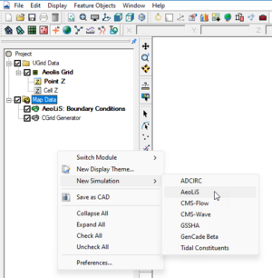
Once the boundary conditions are created, the user must add the coverage to a simulation. To accomplish this, the user must right click in the open space of the SMS project explorer (data tree) and choose "New simulation -> AeoLiS".
One the simulation is created, the user must add the various components to the simulation for Aeolis to correctly export and run.
- Right click on the Boundary Conditions coverage and choose "Apply To" and choose the correct simulation.
- Right click on the UGrid and choose "Apply To" and choose the correct simulation.
Model Control

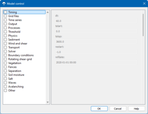
To enter the model control dialog, right click on the simulation and choose "Model Control...". This dialog is shown in Figure 3. The dialog has several different options in the left pane which various parameters available in the right pane. The options for each will become available for entry when that option is selected using the check box.
Usage
It is still early in the development in this tool. It may be available for early testing in SMS 13.4 upon approval from Mitchell Brown. Please contact by email for instructions.
This wiki page will be updated as new features are added.