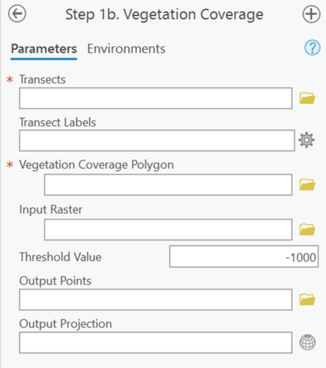
Profile Feature Extraction: Step 1b - Vegetation Coverage

Summary: This step allows for the integration of vegetation coverage layers within the plotting of profiles. The tool inputs shapefiles that represent where vegetation exists and assigns it to point data created in the previous step. This tool is optional and does not change CERI calculations.
Transects: Transects generated previously in this workflow and used for point extraction in Step 1.
Transect Labels: A dropdown menu to select the numbering field from the transect attribute table that provides each of the transects with a unique value (e.g., StTransNum).
Vegetation Coverage Polygon: The polygon that represents the coverage of vegetation in the study area.
Input Raster: The DEM(s) that elevations will be extracted from along each transect. The DEM(s) specified should represent a single survey (see best practices from Step 1).
Threshold Value: The elevation value that specifies false DEM coverage. All values equal to or less than this elevation will be set to null.
Output Points: The full file path, including name and file extension, of the output points file. The file extension can either be a feature class (if in a gdb) or a shapefile (if in a file folder).
Output Projection: Desired projection of the output points. If left blank, projection of output points will be the same as the input transects.