Post-Processing Coastal Modeling System Simulations: Part 2, Calculating Sand Transport Rates
CIRP-WN-11-1
PURPOSE
This Coastal Inlets Research Program Wiki-Note (CHL/CIRP-WN-11-1) is the second in a series that presents methods for analyzing output from Coastal Modeling System (CMS) simulations. Part 1 discussed calculation of volume change from CMS calculations (CHL/CIRP-WN-10-1, Rosati et al. 2010). Herein, Part 2 discusses calculation of sand transport rates using results of a 1-year CMS simulation at Shark River Inlet, New Jersey.
CITATION
 Rosati, J.D., Beck, T.M., and Sanchez, A., 2011, Post-Processing Coastal Modeling System
 Simulations, Part 2, Calculating Sand Transport Rates.Coastal and Hydraulics Engineering
 Wiki-Note CHL/CIRP WN-11-1, Vicksburg, MS: U.S. Army Engineer Research and Development
 Center, http://cirp.usace.army.mil/wiki/Publications:CIRP-WN-11-1
INTRODUCTION
The Coastal Modeling System (CMS) is an integrated wave, current, sand transport, and morphology change numerical model within the Surface Water Modeling System (SMS) (Buttolph et al. 2006, Lin et al. 2008, CIRP 2010, and Wu et al. 2010). The CMS is designed for practical engineering calculations in the coastal zone, including coastal inlets, navigation channels, and adjacent beaches. Processes calculated within the CMS include tide, wind, and wave-driven currents. Forcing stresses caused by Coriolis, wind, bottom friction, and wave radiation are represented, as well as wave interaction with structures such as reflection, diffraction, refraction, transmission, runup, and overtopping. The CMS calculates coastal and inlet processes, sediment transport, and the resulting morphology change for simulation periods ranging from hours to months to up to a year (e.g., Beck and Kraus 2010).
The analyses discussed herein present methods to analyze CMS output for time-averaged sand transport rates. The step-by-step procedure is applied to the CMS output from a study at Shark River Inlet, New Jersey (Beck and Kraus 2010). CMS output files applied herein are available for download: Shark River Inlet Files. The transport program executable is available here: proc_flux files.
OVERVIEW OF SHARK RIVER INLET SIMULATION
The Shark River Inlet calculations were conducted for a 1-year simulation to determine future conditions of the navigation channel under different channel and structural configurations. The model was first calibrated for hydrodynamics, and then for sand transport and morphology change through comparison of pre- and post-dredging bathymetric surveys (conducted by the Corps of Engineers, New York District). For the Shark River application discussed herein, the total load non-equilibrium sediment transport model with Lund-CIRP transport equations were applied and used with the bed change equation to calculate the morphology change. The term "sand transport" is applied herein because the sediment size applied in this study was 0.26 mm sand (Beck and Kraus, 2010). Simulation results were both calibrated and validated based on short-term measurements of channel infilling, following the frequent 3-4 month channel surveys, and with model simulations extending to a year of calculations. The model was forced with the Sandy Hook NOAA tide gauge for water levels and currents, and offshore waves from Wave Information Study (WIS) Station 129 [USACE (2010) Wave Information Studies Project Documentation: WIS Hindcast Database. Developed by the US Corps of Engineer Research and Development Center. http://frf.usace.army.mil/wis2010] for 1994 were applied for wave-current interaction.
CALCULATING SAND TRANSPORT RATES
Calculating accurate sand transport rates is necessary for predicting channeling infilling, inlet and nearshore morphology change, and on a more basic level understanding sand pathways and formulating sand budgets. In the CMS, sand transport statistics are calculated across predefined lines or polygons defined by feature arcs and polygons in a post-processing procedure. The total-load sand transport rates calculated from CMS are integrated across user-defined boundaries. The sand transport statistics are calculated from the integrated sand transport rate. The calculated statistics are the net, gross, positive and negative total-load sand transport rates and are output in units of either cubic yards per foot (cu yd/ft) or cubic meters per meter (m3/m). The following section presents a step-by-step method for calculating longshore sand transport rates using the Shark River Inlet simulation files, although the method can be applied to calculate sand transport rates across any transect (e.g., cross-shore, between tips of jetties, etc). It is important that the user realizes that CMS surf zone and swash zone processes are still being implemented, so sand transport calculations that include the surf and swash zone as calculated by CMS may be lower than measurements and other calculations.
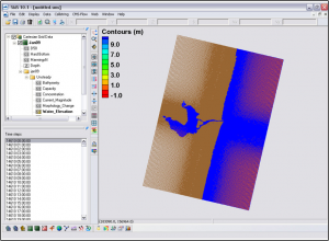
Loading Files: Download the Shark River Inlet calculation file SRI.zip from: Shark River Inlet Files. Load the file Shark River Inlet.cmcards into SMS by dragging it into the SMS or by clicking File | Open | Shark River Inlet.cmcards. The solution file should load in automatically as shown in Figure 1.
Defining Transect for Transport Calculations: This section details how to define a transect or Feature Arc in SMS for calculating transport rates. First, in the project explorer to the left of the SMS window, either change the type of Map coverage to Observation or create a new Map coverage of type Observation. Change the name of the Observation Map Coverage to SRI_Obs_Arcs.
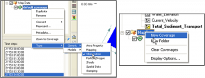
a. To change the type of an existing Map coverage Right-click on the default coverage and select Type | Generic | Observation (Figure 2a); b. To create a new Map coverage, right-click on Map Data in the project explorer, then select New Coverage (Figure 2b).

Next, zoom into the area of interest and create a Feature Arc. Make sure you are in the Map module by clicking on the Map Module Tool or by clicking on Map Data (Figure 3a). The Map Module toolbar should become available in the SMS window. Click on the Create Feature Arc tool (Figure 3b).
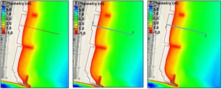
Click on the starting and ending points on the grid that define the Feature Arc for calculating the sand transport statistics. For this example, a Feature Arc extending from the shoreline to offshore is chosen to calculate the longshore sand transport rate (Figure 4a). For longshore transport rate calculations, the Feature Arc should extend beyond the breaker zone and closure depth to capture all, mainly, wave-induced longshore sand transport. Make sure the Feature Arc does not touch inactive land cells as this may cause interpolation problems in the SMS. The positive direction of the sand transport is defined by the Feature Arc’s direction. To view the arc direction, click on the Select Feature Arc tool and right-click on the Feature Arc once. The arrows displayed at the beginning and end of the Feature Arc indicate the direction of the arc which defines the positive for all fluxes or vectors calculated across it (Figure 4b). If necessary, the arc direction may be changed by clicking on the Select Feature Arc tool, and selecting the feature arc by right-clicking it once and selecting the option: Reverse Arc Direction (Figure 4c).

Create Ones Dataset: To integrate the time series of sand transport (a vector) across the Feature Arc, SMS requires a new dataset of the same size and length as the simulation, with constant value of one (named “Ones” Dataset). To create this dataset, select the Cartesian Grid Module (Figure 5a), and click on Data | Data Calculator (Figure 5b).
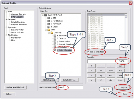
Within the Data Calculator window (Figure 6), select the Water_Elevation dataset to copy and create the Ones Dataset (Step 1). Click on the Use all time steps checkbox (Step 2) and change the name of the output dataset to Ones (Step 3). Double-click on the Water_Elevation dataset so that it appears in the Calculator window (Step 4). In the Calculator, multiply the dataset by zero and then add one (Step 5). Click on Compute (Step 6). The calculation might take a few minutes if the dataset is large. Once the calculation is completed, the output dataset will appear under the Datasets window. The new Ones Dataset will have the same length (duration) as the simulation, but will have values of one. Click on Done to exit the window (Step 7).

Integrating the Sand Transport Time Series: To obtain the sand transport statistics, the sand transport is first integrated spatially to compute a time series of sand transport across the Feature Arc using the SMS Plot Wizard. The sand transport vector field is interpolated to the points where the arc intercepts cell faces and is then integrated across the Feature Arc. First, open the Plot Wizard by clicking on Display | Plot Wizard (Figure 7a) or clicking on the Plot Wizard icon (Figure 7b).
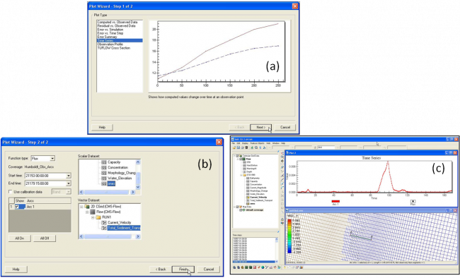
Next, in the Plot Wizard – Step 1 of 2 window (Figure 8a), select Time series as the Plot Type and then click Next>. In the Plot Wizard – Step 2 of 2 window (Figure 8b), select Flux as the function type. Click on the feature arc checkbox. Select the ones dataset for the scalar dataset, and the sand transport as the vector dataset. Make sure the start and end times are correct. Click Finish. The computation might take a few minutes, especially if the dataset is large. The Plot Wizard calculates a time series of integrated sand transport across the Feature Arc (Figure 8c).
Calculating Sand Transport Statistics: There are two ways of calculating the sand transport statistics. One is with a Fortran executable, and the other is with an Excel spreadsheet. A simple Fortran executable is available from proc_flux files that calculates the transport statistics based on a time series of integrated (along arc) transport rates obtained in the previous section. The program can be run from a command prompt, a script file or by simply double clicking on the executable and providing the name of the input file.
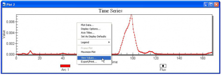
First, right-click on the time series plot and select View Values (Figure 9).
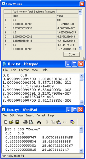
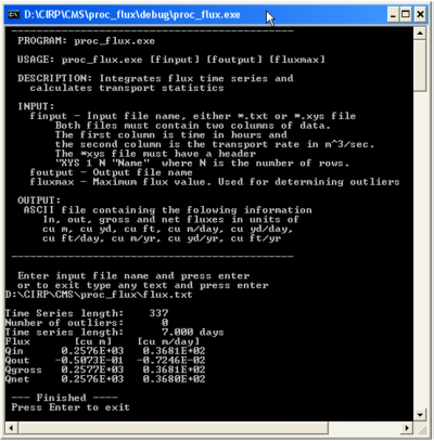
A table will be displayed with the time in hours and integrated sand transport rate across the feature arc (Figure 10a). From the Values window, select all the data and copy-paste it to a text editor such as Wordpad. Note the number of rows in the dataset by looking at the id number of the last row in the View Values window. Save the file with the extension *.txt (see Figure 10b). The data may also be saved as an *.xys file (SMS xy series file). In this case, the file needs a header as shown in Figure 10c, where the first line reads as shown and XYS is the type of file, 1 is the file ID, the next entry is the number of time steps, and the last entry is a name for the time series. Double click on the executable named proc_flux.exe (Figure 11). The executable does not need to be in the same folder as the input file. If the file is not in the same directory, the path should be specified before the file name. If the path contains spaces, quotation marks should be used. Press enter when the executable is finished. If no output file is specified, the default output file name is Flux_statistics.txt. Figure 12 shows an example output file.

RESULTS
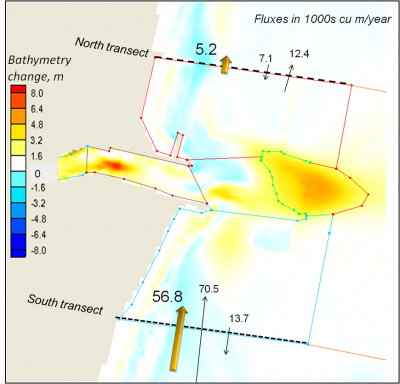
For the example herein, transport rates on transects south (updrift) and north (downdrift) of the inlet were calculated to illustrate the influence of the inlet on sand transport rates. Figure 13 shows a background of morphology change calculations for the 1-year simulation, with transport rates shown on the transects. The program proc_flux.exe calculates the transport across the transect in the direction of the arrows (Qin), transport in the opposite direction (Qout), the gross transport equal to the absolute sum of these two values Qgross = Qin+|Qout|, and the net transport Qnet = Qin+Qout.
As discussed previously, transport arcs that extend through the surf and swash zones may be lower than realistic or measured rates because these processes are still being implemented in CMS. As shown for the Shark River Inlet application (Figure 13), net longshore transport was calculated as approximately 57,000 cu m/year to the north as measured on the south side of the inlet, which reduced to approximately 5,000 cu m/year on the north side of the inlet. Thus, within these transect arcs, the net effect of the inlet is to capture approximately 57,000-5,000 = 52,000 cu m/year. Thus, for this year of wave conditions, these calculations indicate that the ebb shoal, navigation channel, and adjacent beaches within these transect arcs would gain this much sand. Transport across additional arcs could be used to develop a "calculated" sediment budget.
CONCLUSIONS
This WN is Part 2 of a series discussing post-processing of Coastal Modeling System (CMS) simulations. Herein we presented a step-by-step method for integrating CMS calculations of sand transport across user-defined transects. Output files used in the examples are provided for download from Shark River Inlet Files and proc_flux files. With this method, the net and gross longshore sand transport rates for CMS simulations at selected transects can be integrated, compared with accepted values for the region, and used to compare to CMS output. Cross-shore transport rates can be calculated across additional transects such as an inlet channel or into an estuary to develop an understanding of the relative magnitude of sand sources and sinks. Results from these analyses can be applied to adjust CMS setup parameters such that bulk trends in sand transport that are calculated are representative of known or accepted rates.
ADDITIONAL INFORMATION
This WN was prepared as part of the Coastal Inlets Research Program (CIRP) under the Inlet Engineering Toolbox work unit, and was written by Dr. Julie Dean Rosati (Julie.D.Rosati@usace.army.mil), Ms. Tanya Beck (Tanya.M.Beck@usace.army.mil), and Mr. Alejandro Sanchez (Alejandro.Sanchez@usace.army.mil ) of the U.S. Army Engineer Research and Development Center (ERDC), Coastal and Hydraulics Laboratory (CHL). The Shark River Inlet application used to illustrate the method was part of a study conducted for the USACE District, New York. Ashley Frey and Mitch Brown, Coastal Engineering Branch, CHL, reviewed this Wiki-TN. This Wiki-TN should be cited as follows:
Rosati, J.D., Beck, T.M., and Sanchez, A., 2011. Post-Processing Coastal Modeling System Simulations: Part 2, Calculating Sand Transport Rates. Coastal and Hydraulics Engineering Wiki-Technical Note ERDC/CHL/CIRP Wiki-TN-11-1. Vicksburg, MS: U.S. Army Engineer Research and Development Center.
REFERENCES
- Beck, T.M., and Kraus, N.C. 2010. Shark River Inlet, New Jersey, Entrance Shoaling: Report 2, Analysis with Coastal Modeling System. Coastal and Hydraulics Laboratory Technical Report 10-4. Vicksburg, MS: U.S. Army Engineer Research and Development Center, U.S.A.
- Buttolph, A.M., Reed, C.W., Kraus, N.C., Ono, N., Larson, M., Carmenen, B., Hanson, H., Wamsley, T., and Zundel, A.K. 2006. Two-dimensional depth-averaged circulation model CMS-M2D: Version 3.0, Report 2: Sand transport and morphology change. Coastal and Hydraulics Laboratory Technical Report ERDC/CHL TR-06-9. Vicksburg, MS: U.S. Army Engineer Research and Development Center, U.S.A.
- Coastal Inlets Research Program (CIRP), 2010. CIRP wiki – CMS. http://cirp.usace.army.mil/wiki/CMS , last updated 28 July 2010, accessed 16 August 2010.
- Lin, L., Demirbilek, Z., Mase, H., Zheng, J., and Yamada, F. 2008. CMS-Wave: A nearshore spectral wave processes model for coastal inlets and navigation projects. Coastal and Hydraulics Laboratory Technical Report ERDC/CHL TR-08-13, Vicksburg, MS: U.S. Army Engineer Research and Development Center, U.S.A.
- Rosati, J.D., Beck, T.M., and Sanchez, A., 2010. Post-Processing Coastal Modeling System Simulations, Part 1, Calculating Volumetric Change. Coastal and Hydraulics Laboratory Wiki-Note CHL/CIRP WN-11-1, Vicksburg, MS: U.S. Army Engineer Research and Development Center, http://cirp.usace.army.mil/wiki/Publications:CIRP-WN-10-1
- Wu, W., Zhang, M., and Sanchez, A. 2010. An implicit 2-D shallow water flow model on unstructured quadtree rectangular mesh. J. Coastal Res., in press.
- Zundel, A. K., 2000. Surface-water modeling system reference manual. Brigham Young University, Environmental Modeling Research Laboratory, Provo, UT.
| ||||||||||||||||||||||||||