Rhode Island Regional Sediment Management
UNDER CONSTRUCTION

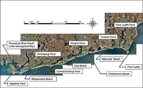
The project site is the south shore of Rhode Island and it consists of a series of glacial outwash headlands, barrier islands, and salt ponds. Washington County’s 24 miles of coastline includes two Federal navigation channels (Little Narragansett Bay and Point Judith Harbor), a Federal Harbor of Refuge (Point Judith Harbor of Refuge), a newly completed Section 206 habitat restoration project in Ninigret Pond (removing portions of flood shoal delta for habitat restoration) and two proposed Section 206 projects for Quonochontaug and Winnapaug Ponds (removing portions of flood shoal deltas for habitat restoration). This results in 3 Federal navigation projects and six existing/proposed Federal projects all of which involve the movement/placement of sediment within 24 miles of shoreline. Additionally, the Point Judith Harbor of Refuge is presently being investigated for a potential $20 million breakwater repair.
While individual studies have been completed or are underway for these projects, a comprehensive regional approach has never been attempted here. Almost the entire southern shore of RI within Washington County is eroding with significant losses in many areas. Losses are directly impacting beach front structures/infrastructure and are threatening the barrier beaches fronting the critically important salt ponds. The barrier beaches provide protection to the more highly developed areas along the interior shorelines of the ponds as well as areas of important marine wetland habitat. For these reasons it is critically important to better understand and manage sediment resources within the system.
Project Objectives
The study will develop a Regional Sediment Management Plan. This plan will include:
- Location/quantification of sediment sources and sediment sinks
- Sediment transport characteristics
- Quantification and interpretation of past shoreline changes
- Establishment and testing of techniques for assessing shoreline response to natural forces and human activity on local and regional bases
- Ecosystem evaluation
- Sea level rise impacts
- Locating potential sources for beach fill projects
- Enhanced operational practices at Federal navigation projects
- Developing a means of information dissemination from the study to all interested parties, including governmental planning, engineering and regulatory agencies, and other stakeholders interested in the coast of Washington County in RI.
Model Setup
To identify pathways of sediment transport in the system, the CMS will be used. The CMS modeling efforts will feature a nested grid approach with telescoping grid. The telescoping grid approach allows the user to optimize grid refinement simultaneously with computational time. The nested grid approach will allow each pond to be modeled individually while a regional grid will be developed to capture the wave and current fields in the larger scale. Model grids have been developed to aid in siting ADCP locations by examining the shadow effect Block Island has on the nearshore zone.
Validation

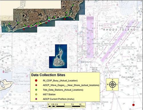
CMS modeling is ongoing and will be validated using field data. An extensive real-time field data collection program is currently underway. Figure 2 details the locations of gauges within the project site.
Field Data Includes:
- 14 Tide Gauges
- Bottom Mounted ADCPs at -10m contour
- Meterological Station
- Inlet Current Measurements
- 2010 LIDAR Flight
To see a snapshot of the real-time gauges visit [| RI-RSM Real Time Wave, Current, Tide, and Meteorological Data Collection Stations]
In addition to the field data collection program described above, a permanent directional wave gauge was deployed offshore of Block Island to represent the offshore boundary condition for the model. This buoy will aid in future studies including Pt Judith Harbor of Refuge. All data is available real time
Directional Wave Data: [| CDIP 154]
Discussion
References
- Watts, I.M., et al. (2011) "Rhode Island Regional Sediment Management" Shore and Beach, Vol 29, No. 3, 1-5. in press.
- Winkelman, J. H. et al, (2011) "Ninigret Pond, RI Flood Shoal Dredging/Sediment Basin Creation for Habitat Restoration Performance Evaluation" Coastal Sediments '11 Conference Proceedings
| CHETN-IV-76]] Lin, L., Watts, I., Demirbilek, Z. (2010) "CMS-Wave Model: Part 3: Grid Nesting and Application Example for Rhode Island South Shore Regional Sediment Management Study" ERDC/CHL CHETN-IV-76
- Thomas, J., Boicourt, W., Kerkering, H., Leonard, L., Ostrander, C., Watts, I. (2010). "IOOS Contributions to the Decision-Making Process for Mariners and Coastal Managers" Marine Technology Society Journal Vol 44, No 6.
- Watts, I. M. (2010) "The Great Mid-Atlantic Storm of 2009: The 'Friday the 13th' Storm Observations in the New England District" Shore and Beach, Vol 78, No. 2, 26-28.