Tutorials: Difference between revisions
No edit summary |
|||
| Line 21: | Line 21: | ||
<br style="clear:both" /> | <br style="clear:both" /> | ||
==3. [[Calculating Volumetric Changes | Calculating Volumetric Changes]]== | ==3. [[Calculating Volumetric Changes | Calculating Volumetric Changes]]== | ||
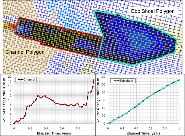
[[File:VolChg_Fig9.png|thumb|right|600px|Calculation of Shark River Inlet channel infilling over a one-year period showing exponentially-decreasing trend.]] | |||
The analyses discussed herein present methods to analyze CMS output for volumetric change within a defined polygon such as a section of a navigation channel or a morphologic feature such as an ebb shoal. The step-by-step procedure is applied to CMS output from a study at Shark River Inlet, New Jersey (Beck and Kraus 2010). | |||
Calculating volume change is necessary for determining rates of channel infilling, inlet shoal evolution, and on a more basic level understanding sand pathways and formulating sand budgets. In the CMS, volume change can be calculated for any polygon defined by feature arcs in the SMS. The following section presents a step-by-step method for calculating volumetric change using the Shark River Inlet simulation files. | |||
<br style="clear:both" /> | <br style="clear:both" /> | ||
==4. [[Grays Harbor | Grays Harbor, WA '''Under Construction''']]== | ==4. [[Grays Harbor | Grays Harbor, WA '''Under Construction''']]== | ||
Revision as of 16:11, 17 January 2011
Under Construction
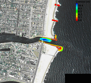
1. Shark River Inlet, NJ Workshop Tutorial

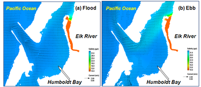
2. Salinity Calculation at Humboldt Bay, CA

- In this section, the salinity modeling is described to demonstrate the CMS capability at Humboldt Bay, CA. The tutorial covers
3. Calculating Volumetric Changes

The analyses discussed herein present methods to analyze CMS output for volumetric change within a defined polygon such as a section of a navigation channel or a morphologic feature such as an ebb shoal. The step-by-step procedure is applied to CMS output from a study at Shark River Inlet, New Jersey (Beck and Kraus 2010).
Calculating volume change is necessary for determining rates of channel infilling, inlet shoal evolution, and on a more basic level understanding sand pathways and formulating sand budgets. In the CMS, volume change can be calculated for any polygon defined by feature arcs in the SMS. The following section presents a step-by-step method for calculating volumetric change using the Shark River Inlet simulation files.